Gomadingen elevation
Gomadingen (Baden-Württemberg, Tübingen Region), Germany elevation is 664 meters and Gomadingen elevation in feet is 2178 ft above sea level [src 1]. Gomadingen is a seat of a fourth-order administrative division (feature code) with elevation that is 406 meters (1332 ft) bigger than average city elevation in Germany.
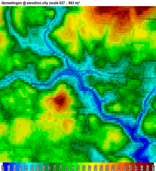
Below is the Elevation map of Gomadingen, which displays elevation range with different colors. Scale of the first map is from 637 to 863 m (2090 to 2831 ft) with average elevation of 728 meters (=2388 ft) [note 1]
These maps also provides idea of topography and contour of this city, they are displayed at different zoom levels. More info about maps, scale and edge coordinates you can find below images.
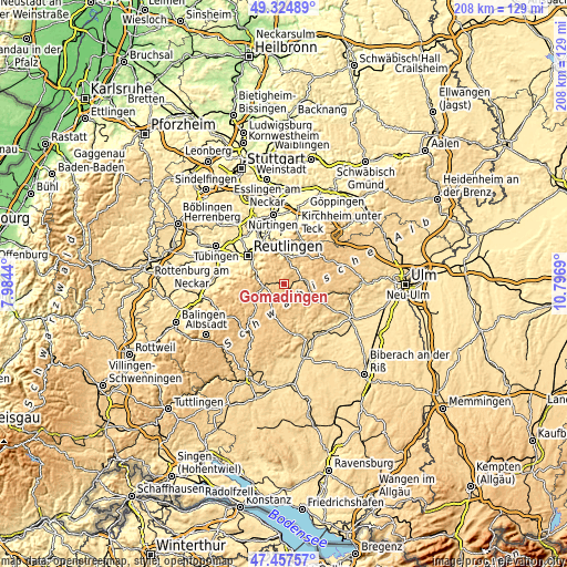
| \ | Map #1 | Topo.Map |
| Scale [m] | 637..863 m | × |
| Scale [ft] | 2090..2831 ft | × |
| Average | 728 m = 2388 ft | × |
| Width | 6.49 km = 4 mi | 207.6 km = 129 mi |
| Height | 6.49 km = 4 mi | 207.6 km = 129 mi |
| ↑Max Latitude | 48.428968° | 49.32489° |
| Latitude at center | 48.3998° | 48.3998° |
| ↓Min Latitude | 48.370615° | 47.45757° |
| ← Min Longitude | 9.346705° | 7.9844° |
| Longitude center | 9.39065° | 9.39065° |
| →Max Longitude | 9.434595° | 10.7969° |
Nearby cities:
Cities around Gomadingen sort by population:
• Pfullingen elevation 429 m
14 km,  300°
300°
• Münsingen 714 m
8 km,  80°
80°
• Altes Lager 794 m
10.9 km, 79°
• Bad Urach 463 m
10.2 km,  3°
3°
• Eningen unter Achalm 464 m
13.7 km,  315°
315°
• Unterhausen 509 m
10.5 km,  288°
288°
• Trochtelfingen 695 m
14.8 km,  226°
226°
• Sankt Johann 732 m
6.9 km,  330°
330°
• Hülben 714 m
13.4 km,  5°
5°
• Pfronstetten 754 m
13.9 km,  189°
189°
• Grabenstetten 714 m
14.8 km,  20°
20°
• Mehrstetten 755 m
13.2 km,  101°
101°
Multilingual:
 En español:
Gomadingen elevación 664 m.
 En France:
Gomadingen élévation 664 m.
 Auf Deutsch:
Gomadingen höhe über dem Meeresspiegel ist 664 m.

Sources and notes:
- [note 1] Map square and city borders are not equal. Map elevation data is calculated only from area inside that square.
- [src 1] Elevation data from geonames database provided with same terms of usage.
- [src 2] The elevation map of Gomadingen is generated using elevation data from NASA's 3 arcsec (90m) resolution SRTM data.
- [src 3] Base (background) map © OpenStreetMap contributors tiles are generated by Geofabrik and OpenTopoMap.
Copyright & License:
This Gomadingen Elevation Map is licensed under CC BY-SA. You may reuse any part from this page, if you give a proper credit by linking to this URL:
 More info on terms of use page.