Hülben elevation
Hülben (Baden-Württemberg, Tübingen Region), Germany elevation is 714 meters and Hülben elevation in feet is 2343 ft above sea level [src 1]. Hülben is a seat of a fourth-order administrative division (feature code) with elevation that is 456 meters (1496 ft) bigger than average city elevation in Germany.
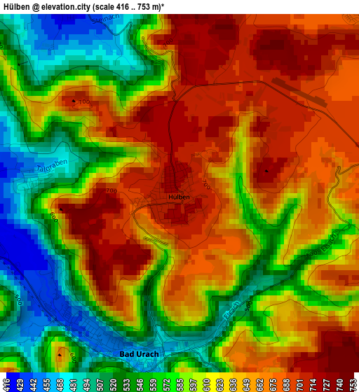
Below is the Elevation map of Hülben, which displays elevation range with different colors. Scale of the first map is from 416 to 753 m (1365 to 2470 ft) with average elevation of 616.6 meters (=2023 ft) [note 1]
These maps also provides idea of topography and contour of this city, they are displayed at different zoom levels. More info about maps, scale and edge coordinates you can find below images.
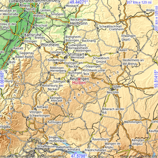
| \ | Map #1 | Topo.Map |
| Scale [m] | 416..753 m | × |
| Scale [ft] | 1365..2470 ft | × |
| Average | 616.6 m = 2023 ft | × |
| Width | 6.47 km = 4 mi | 207.1 km = 128.7 mi |
| Height | 6.47 km = 4 mi | 207.1 km = 128.7 mi |
| ↑Max Latitude | 48.548919° | 49.44271° |
| Latitude at center | 48.51982° | 48.51982° |
| ↓Min Latitude | 48.490704° | 47.5798° |
| ← Min Longitude | 9.363955° | 8.00165° |
| Longitude center | 9.4079° | 9.4079° |
| →Max Longitude | 9.451845° | 10.81415° |
Nearby cities:
Cities around Hülben sort by population:
• Metzingen elevation 350 m
9.4 km,  281°
281°
• Bad Urach 463 m
3.2 km,  190°
190°
• Dettingen an der Erms 396 m
4.8 km, 284°
• Frickenhausen 322 m
8.9 km,  336°
336°
• Lenningen 466 m
6.1 km,  56°
56°
• Neuffen 404 m
4.5 km,  328°
328°
• Sankt Johann 732 m
8.7 km,  212°
212°
• Owen 389 m
8.1 km,  22°
22°
• Beuren 435 m
5.5 km,  357°
357°
• Kohlberg 468 m
6.8 km,  308°
308°
• Erkenbrechtsweiler 702 m
4.5 km, 23°
• Grabenstetten 714 m
4 km,  83°
83°
Multilingual:
 En español:
Hülben elevación 714 m.
 En France:
Hülben élévation 714 m.


Sources and notes:
- [note 1] Map square and city borders are not equal. Map elevation data is calculated only from area inside that square.
- [src 1] Elevation data from geonames database provided with same terms of usage.
- [src 2] The elevation map of Hülben is generated using elevation data from NASA's 3 arcsec (90m) resolution SRTM data.
- [src 3] Base (background) map © OpenStreetMap contributors tiles are generated by Geofabrik and OpenTopoMap.
Copyright & License:
This Hülben Elevation Map is licensed under CC BY-SA. You may reuse any part from this page, if you give a proper credit by linking to this URL:
 More info on terms of use page.