Grimma elevation
Grimma (Saxony), Germany elevation is 143 meters and Grimma elevation in feet is 469 ft above sea level [src 1]. Grimma is a populated place (feature code) with elevation that is 115 meters (377 ft) smaller than average city elevation in Germany.
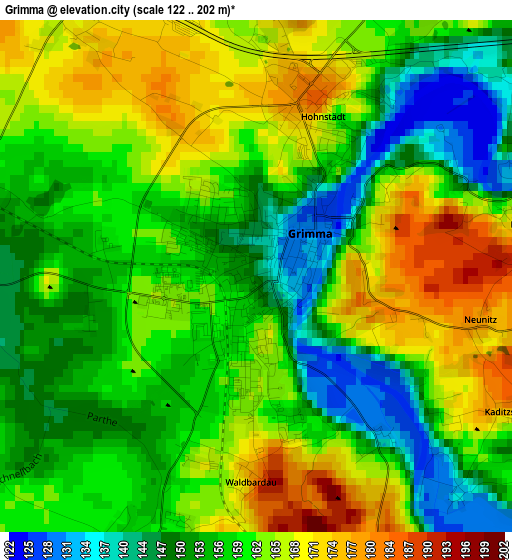
Below is the Elevation map of Grimma, which displays elevation range with different colors. Scale of the first map is from 122 to 202 m (400 to 663 ft) with average elevation of 159.2 meters (=522 ft) [note 1]
These maps also provides idea of topography and contour of this city, they are displayed at different zoom levels. More info about maps, scale and edge coordinates you can find below images.
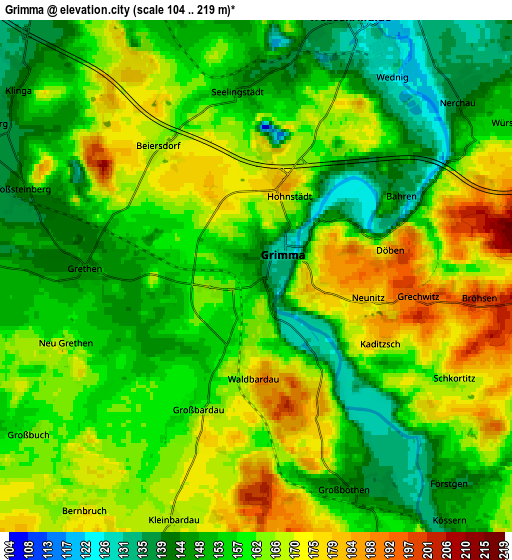
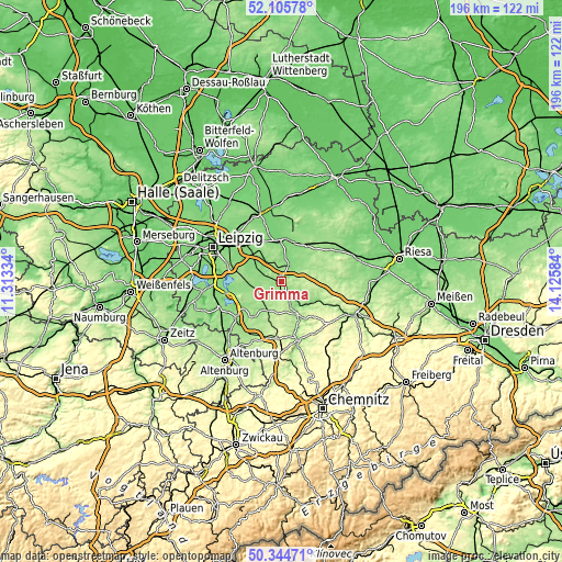
| \ | Map #1 | Map #2 | Topo.Map |
| Scale [m] | 122..202 m | 104..219 m | × |
| Scale [ft] | 400..663 ft | 341..719 ft | × |
| Average | 159.2 m = 522 ft | 159.4 m = 523 ft | × |
| Width | 6.12 km = 3.8 mi | 12.24 km = 7.6 mi | 195.8 km = 121.7 mi |
| Height | 6.12 km = 3.8 mi | 12.24 km = 7.6 mi | 195.8 km = 121.7 mi |
| ↑Max Latitude | 51.261178° | 51.288669° | 52.10578° |
| Latitude at center | 51.23367° | 51.23367° | 51.23367° |
| ↓Min Latitude | 51.206146° | 51.178605° | 50.34471° |
| ← Min Longitude | 12.675645° | 12.631699° | 11.31334° |
| Longitude center | 12.71959° | 12.71959° | 12.71959° |
| →Max Longitude | 12.763535° | 12.807481° | 14.12584° |
Nearby cities:
Cities around Grimma sort by population:
• Bad Lausick elevation 175 m
11.2 km,  207°
207°
• Naunhof 133 m
10.4 km,  298°
298°
• Colditz 148 m
13.1 km,  153°
153°
• Ostrau 184 m
11.9 km,  104°
104°
• Trebsen 129 m
6.6 km,  21°
21°
• Nerchau 138 m
6.4 km,  49°
49°
• Zschadrass 223 m
12.6 km, 146°
• Großbothen 143 m
5.5 km,  156°
156°
• Belgershain 151 m
11.8 km,  269°
269°
• Mutzschen 189 m
12.3 km,  75°
75°
• Großbardau 161 m
3.6 km,  204°
204°
• Otterwisch 154 m
8.1 km,  242°
242°
Multilingual:
 En español:
Grimma elevación 143 m.
 En France:
Grimma élévation 143 m.


Sources and notes:
- [note 1] Map square and city borders are not equal. Map elevation data is calculated only from area inside that square.
- [src 1] Elevation data from geonames database provided with same terms of usage.
- [src 2] The elevation map of Grimma is generated using elevation data from NASA's 3 arcsec (90m) resolution SRTM data.
- [src 3] Base (background) map © OpenStreetMap contributors tiles are generated by Geofabrik and OpenTopoMap.
Copyright & License:
This Grimma Elevation Map is licensed under CC BY-SA. You may reuse any part from this page, if you give a proper credit by linking to this URL:
 More info on terms of use page.