Zschadrass elevation
Zschadrass (Saxony), Germany elevation is 223 meters and Zschadrass elevation in feet is 732 ft above sea level [src 1]. Zschadrass is a populated place (feature code) with elevation that is 35 meters (115 ft) smaller than average city elevation in Germany.
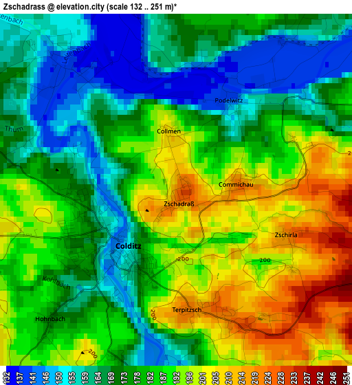
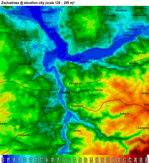
Below is the Elevation map of Zschadrass, which displays elevation range with different colors. Scale of the first map is from 132 to 251 m (433 to 823 ft) with average elevation of 180.5 meters (=592 ft) [note 1]
These maps also provides idea of topography and contour of this city, they are displayed at different zoom levels. More info about maps, scale and edge coordinates you can find below images.
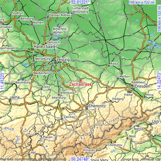
| \ | Map #1 | Map #2 | Topo.Map |
| Scale [m] | 132..251 m | 129..299 m | × |
| Scale [ft] | 433..823 ft | 423..981 ft | × |
| Average | 180.5 m = 592 ft | 193.8 m = 636 ft | × |
| Width | 6.13 km = 3.8 mi | 12.26 km = 7.6 mi | 196.2 km = 121.9 mi |
| Height | 6.13 km = 3.8 mi | 12.26 km = 7.6 mi | 196.2 km = 121.9 mi |
| ↑Max Latitude | 51.165845° | 51.193393° | 52.01221° |
| Latitude at center | 51.13828° | 51.13828° | 51.13828° |
| ↓Min Latitude | 51.110699° | 51.083101° | 50.24749° |
| ← Min Longitude | 12.774535° | 12.730589° | 11.41223° |
| Longitude center | 12.81848° | 12.81848° | 12.81848° |
| →Max Longitude | 12.862425° | 12.906371° | 14.22473° |
Nearby cities:
Cities around Zschadrass sort by population:
• Hartha elevation 262 m
11.7 km,  112°
112°
• Leisnig 221 m
7.9 km,  74°
74°
• Rochlitz 167 m
9.9 km,  188°
188°
• Colditz 148 m
1.6 km,  224°
224°
• Geringswalde 252 m
9.2 km,  137°
137°
• Ostrau 184 m
8.9 km,  31°
31°
• Großbothen 143 m
7.2 km,  319°
319°
• Bockelwitz 215 m
11.8 km,  54°
54°
• Seelitz 228 m
11.7 km,  180°
180°
• Großbardau 161 m
11.1 km,  311°
311°
• Königsfeld 234 m
9.3 km,  210°
210°
• Gersdorf 269 m
8.9 km, 109°
Multilingual:
 En español:
Zschadrass elevación 223 m.
 En France:
Zschadrass élévation 223 m.
 Auf Deutsch:
Zschadrass höhe über dem Meeresspiegel ist 223 m.

Sources and notes:
- [note 1] Map square and city borders are not equal. Map elevation data is calculated only from area inside that square.
- [src 1] Elevation data from geonames database provided with same terms of usage.
- [src 2] The elevation map of Zschadrass is generated using elevation data from NASA's 3 arcsec (90m) resolution SRTM data.
- [src 3] Base (background) map © OpenStreetMap contributors tiles are generated by Geofabrik and OpenTopoMap.
Copyright & License:
This Zschadrass Elevation Map is licensed under CC BY-SA. You may reuse any part from this page, if you give a proper credit by linking to this URL:
 More info on terms of use page.