Gronau elevation
Gronau (Lower Saxony), Germany elevation is 81 meters and Gronau elevation in feet is 266 ft above sea level [src 1]. Gronau is a populated place (feature code) with elevation that is 177 meters (581 ft) smaller than average city elevation in Germany.
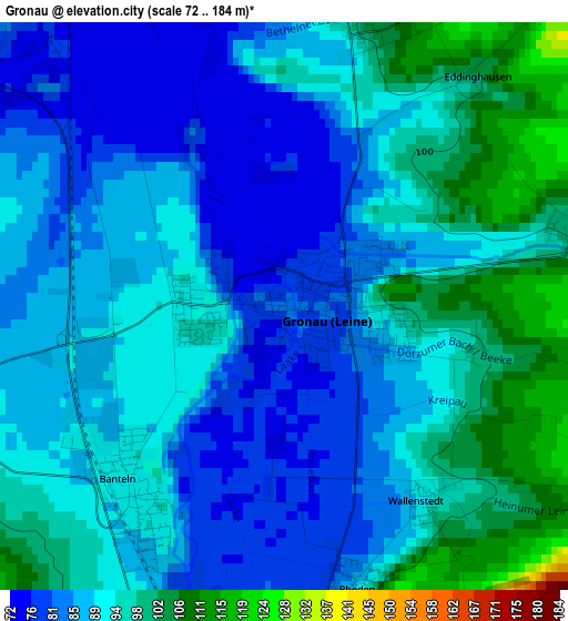
Below is the Elevation map of Gronau, which displays elevation range with different colors. Scale of the first map is from 72 to 184 m (236 to 604 ft) with average elevation of 90.3 meters (=296 ft) [note 1]
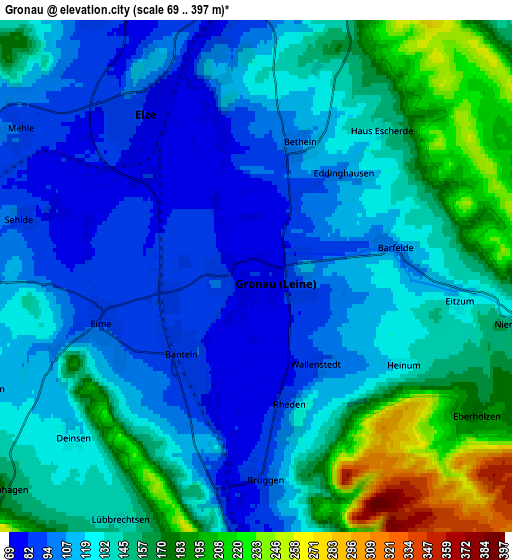
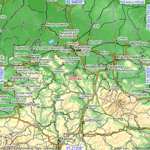
These maps also provides idea of topography and contour of this city, they are displayed at different zoom levels. More info about maps, scale and edge coordinates you can find below images.
| \ | Map #1 | Map #2 | Topo.Map |
| Scale [m] | 72..184 m | 69..397 m | × |
| Scale [ft] | 236..604 ft | 226..1302 ft | × |
| Average | 90.3 m = 296 ft | 135.1 m = 443 ft | × |
| Width | 6.01 km = 3.7 mi | 12.01 km = 7.5 mi | 192.2 km = 119.4 mi |
| Height | 6.01 km = 3.7 mi | 12.01 km = 7.5 mi | 192.2 km = 119.4 mi |
| ↑Max Latitude | 52.111596° | 52.138576° | 52.94039° |
| Latitude at center | 52.0846° | 52.0846° | 52.0846° |
| ↓Min Latitude | 52.057588° | 52.030559° | 51.21208° |
| ← Min Longitude | 9.732835° | 9.688889° | 8.37053° |
| Longitude center | 9.77678° | 9.77678° | 9.77678° |
| →Max Longitude | 9.820725° | 9.864671° | 11.18303° |
Nearby cities:
Cities around Gronau sort by population:
• Nordstemmen elevation 76 m
8.6 km,  3°
3°
• Elze 93 m
5.1 km,  326°
326°
• Diekholzen 122 m
9.8 km,  82°
82°
• Duingen 204 m
10.5 km,  211°
211°
• Eime 93 m
4 km,  253°
253°
• Sibbesse 191 m
9.3 km,  114°
114°
• Banteln 92 m
2.7 km,  222°
222°
• Rheden 90 m
3.1 km,  166°
166°
• Betheln 105 m
3.5 km,  19°
19°
• Heyersum 96 m
8.4 km, 16°
• Brüggen 89 m
4.7 km,  181°
181°
• Heinsen 149 m
8.1 km, 252°
Multilingual:
 En español:
Gronau elevación 81 m.
 En France:
Gronau élévation 81 m.


Sources and notes:
- [note 1] Map square and city borders are not equal. Map elevation data is calculated only from area inside that square.
- [src 1] Elevation data from geonames database provided with same terms of usage.
- [src 2] The elevation map of Gronau is generated using elevation data from NASA's 3 arcsec (90m) resolution SRTM data.
- [src 3] Base (background) map © OpenStreetMap contributors tiles are generated by Geofabrik and OpenTopoMap.
Copyright & License:
This Gronau Elevation Map is licensed under CC BY-SA. You may reuse any part from this page, if you give a proper credit by linking to this URL:
 More info on terms of use page.