Gusterath elevation
Gusterath (Rheinland-Pfalz), Germany elevation is 335 meters and Gusterath elevation in feet is 1099 ft above sea level [src 1]. Gusterath is a seat of a fourth-order administrative division (feature code) with elevation that is 77 meters (253 ft) bigger than average city elevation in Germany.
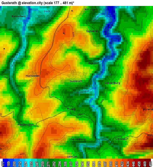
Below is the Elevation map of Gusterath, which displays elevation range with different colors. Scale of the first map is from 177 to 481 m (581 to 1578 ft) with average elevation of 336.1 meters (=1103 ft) [note 1]
These maps also provides idea of topography and contour of this city, they are displayed at different zoom levels. More info about maps, scale and edge coordinates you can find below images.
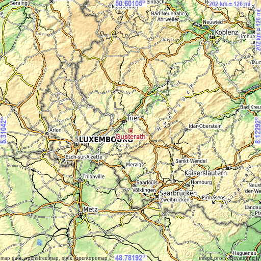
| \ | Map #1 | Topo.Map |
| Scale [m] | 177..481 m | × |
| Scale [ft] | 581..1578 ft | × |
| Average | 336.1 m = 1103 ft | × |
| Width | 6.32 km = 3.9 mi | 202.3 km = 125.7 mi |
| Height | 6.32 km = 3.9 mi | 202.3 km = 125.7 mi |
| ↑Max Latitude | 49.728415° | 50.60105° |
| Latitude at center | 49.7° | 49.7° |
| ↓Min Latitude | 49.671568° | 48.78192° |
| ← Min Longitude | 6.672725° | 5.31042° |
| Longitude center | 6.71667° | 6.71667° |
| →Max Longitude | 6.760615° | 8.12292° |
Nearby cities:
Cities around Gusterath sort by population:
• Trier elevation 141 m
8.3 km,  318°
318°
• Irsch 230 m
3.2 km,  335°
335°
• Fell 195 m
8.8 km,  32°
32°
• Osburg 438 m
5.1 km,  68°
68°
• Waldrach 204 m
5.5 km,  21°
21°
• Mertesdorf 209 m
8.1 km,  8°
8°
• Wiltingen 157 m
10 km,  243°
243°
• Schillingen 485 m
8.8 km,  147°
147°
• Pluwig 310 m
1.2 km,  195°
195°
• Kasel 170 m
7 km, 9°
• Thomm 464 m
7.8 km,  54°
54°
• Pellingen 442 m
4.3 km,  230°
230°
Multilingual:
 En español:
Gusterath elevación 335 m.
 En France:
Gusterath élévation 335 m.
 Auf Deutsch:
Gusterath höhe über dem Meeresspiegel ist 335 m.

Sources and notes:
- [note 1] Map square and city borders are not equal. Map elevation data is calculated only from area inside that square.
- [src 1] Elevation data from geonames database provided with same terms of usage.
- [src 2] The elevation map of Gusterath is generated using elevation data from NASA's 3 arcsec (90m) resolution SRTM data.
- [src 3] Base (background) map © OpenStreetMap contributors tiles are generated by Geofabrik and OpenTopoMap.
Copyright & License:
This Gusterath Elevation Map is licensed under CC BY-SA. You may reuse any part from this page, if you give a proper credit by linking to this URL:
 More info on terms of use page.