Schillingen elevation
Schillingen (Rheinland-Pfalz), Germany elevation is 485 meters and Schillingen elevation in feet is 1591 ft above sea level [src 1]. Schillingen is a seat of a fourth-order administrative division (feature code) with elevation that is 227 meters (745 ft) bigger than average city elevation in Germany.
Below is the Elevation map of Schillingen, which displays elevation range with different colors. Scale of the first map is from 356 to 623 m (1168 to 2044 ft) with average elevation of 491.3 meters (=1612 ft) [note 1]
These maps also provides idea of topography and contour of this city, they are displayed at different zoom levels. More info about maps, scale and edge coordinates you can find below images.
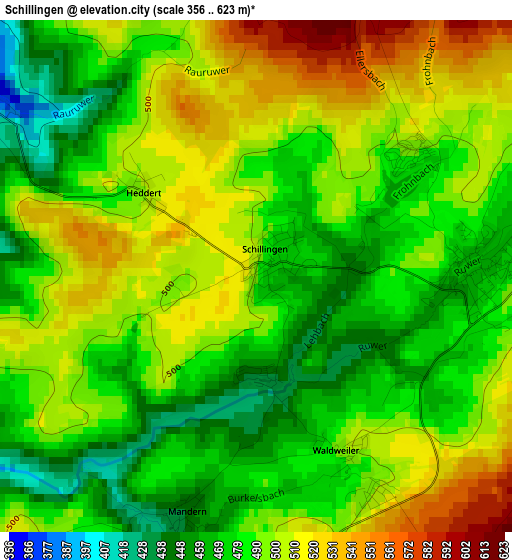
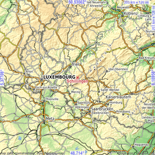
| \ | Map #1 | Topo.Map |
| Scale [m] | 356..623 m | × |
| Scale [ft] | 1168..2044 ft | × |
| Average | 491.3 m = 1612 ft | × |
| Width | 6.33 km = 3.9 mi | 202.5 km = 125.8 mi |
| Height | 6.33 km = 3.9 mi | 202.5 km = 125.8 mi |
| ↑Max Latitude | 49.661784° | 50.53562° |
| Latitude at center | 49.63333° | 49.63333° |
| ↓Min Latitude | 49.604859° | 48.714° |
| ← Min Longitude | 6.739385° | 5.37708° |
| Longitude center | 6.78333° | 6.78333° |
| →Max Longitude | 6.827275° | 8.18958° |
Nearby cities:
Cities around Schillingen sort by population:
• Weiskirchen elevation 352 m
9.6 km,  165°
165°
• Hermeskeil 526 m
11.8 km,  78°
78°
• Irsch 230 m
12 km,  329°
329°
• Reinsfeld 503 m
9.1 km,  52°
52°
• Osburg 438 m
9.3 km,  0°
0°
• Kell 467 m
2.9 km,  87°
87°
• Gusterath 335 m
8.8 km, 327°
• Zerf 364 m
8.1 km,  242°
242°
• Pluwig 310 m
8.1 km,  320°
320°
• Gusenburg 490 m
8.4 km, 90°
• Pellingen 442 m
9.4 km,  300°
300°
• Greimerath 436 m
10.7 km,  221°
221°
Multilingual:
 En español:
Schillingen elevación 485 m.
 En France:
Schillingen élévation 485 m.
 Auf Deutsch:
Schillingen höhe über dem Meeresspiegel ist 485 m.

Sources and notes:
- [note 1] Map square and city borders are not equal. Map elevation data is calculated only from area inside that square.
- [src 1] Elevation data from geonames database provided with same terms of usage.
- [src 2] The elevation map of Schillingen is generated using elevation data from NASA's 3 arcsec (90m) resolution SRTM data.
- [src 3] Base (background) map © OpenStreetMap contributors tiles are generated by Geofabrik and OpenTopoMap.
Copyright & License:
This Schillingen Elevation Map is licensed under CC BY-SA. You may reuse any part from this page, if you give a proper credit by linking to this URL:
 More info on terms of use page.