Hagen elevation
Hagen (North Rhine-Westphalia, Regierungsbezirk Arnsberg), Germany elevation is 111 meters and Hagen elevation in feet is 364 ft above sea level [src 1]. Hagen is a seat of a third-order administrative division (feature code) with elevation that is 147 meters (482 ft) smaller than average city elevation in Germany.
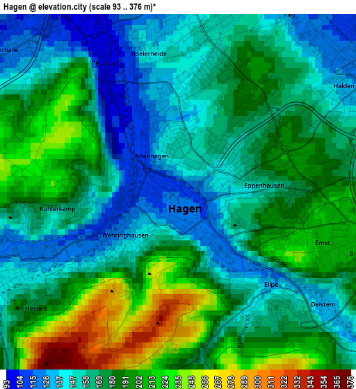
Below is the Elevation map of Hagen, which displays elevation range with different colors. Scale of the first map is from 93 to 376 m (305 to 1234 ft) with average elevation of 174.8 meters (=573 ft) [note 1]
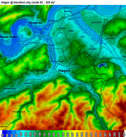
These maps also provides idea of topography and contour of this city, they are displayed at different zoom levels. More info about maps, scale and edge coordinates you can find below images.
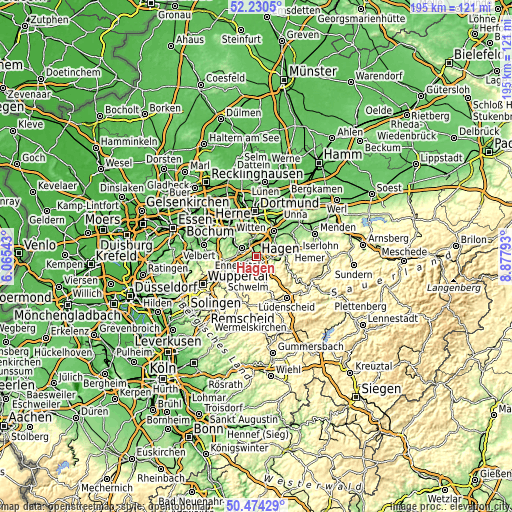
| \ | Map #1 | Map #2 | Topo.Map |
| Scale [m] | 93..376 m | 52..424 m | × |
| Scale [ft] | 305..1234 ft | 171..1391 ft | × |
| Average | 174.8 m = 573 ft | 196.7 m = 645 ft | × |
| Width | 6.1 km = 3.8 mi | 12.2 km = 7.6 mi | 195.3 km = 121.4 mi |
| Height | 6.1 km = 3.8 mi | 12.2 km = 7.6 mi | 195.3 km = 121.4 mi |
| ↑Max Latitude | 51.388242° | 51.415657° | 52.2305° |
| Latitude at center | 51.36081° | 51.36081° | 51.36081° |
| ↓Min Latitude | 51.333362° | 51.305897° | 50.47429° |
| ← Min Longitude | 7.427735° | 7.383789° | 6.06543° |
| Longitude center | 7.47168° | 7.47168° | 7.47168° |
| →Max Longitude | 7.515625° | 7.559571° | 8.87793° |
Nearby cities:
Cities around Hagen sort by population:
• Witten elevation 119 m
12.4 km,  318°
318°
• Schwerte 124 m
11.4 km,  35°
35°
• Gevelsberg 166 m
10.3 km,  243°
243°
• Ennepetal 197 m
10.3 km,  227°
227°
• Schwelm 229 m
14.9 km, 236°
• Wetter (Ruhr) 126 m
6.2 km,  298°
298°
• Sprockhövel 228 m
15.9 km,  264°
264°
• Herdecke 114 m
5 km,  330°
330°
• Altena 167 m
15.8 km,  117°
117°
• Schalksmühle 253 m
13.9 km,  163°
163°
• Breckerfeld 388 m
11.3 km,  181°
181°
• Nachrodt-Wiblingwerde 419 m
11.2 km, 115°
Multilingual:
 En español:
Hagen elevación 111 m.
 En France:
Hagen élévation 111 m.


Sources and notes:
- [note 1] Map square and city borders are not equal. Map elevation data is calculated only from area inside that square.
- [src 1] Elevation data from geonames database provided with same terms of usage.
- [src 2] The elevation map of Hagen is generated using elevation data from NASA's 3 arcsec (90m) resolution SRTM data.
- [src 3] Base (background) map © OpenStreetMap contributors tiles are generated by Geofabrik and OpenTopoMap.
Copyright & License:
This Hagen Elevation Map is licensed under CC BY-SA. You may reuse any part from this page, if you give a proper credit by linking to this URL:
 More info on terms of use page.