Halbe elevation
Halbe (Brandenburg), Germany elevation is 50 meters and Halbe elevation in feet is 164 ft above sea level [src 1]. Halbe is a seat of a fourth-order administrative division (feature code) with elevation that is 208 meters (682 ft) smaller than average city elevation in Germany.
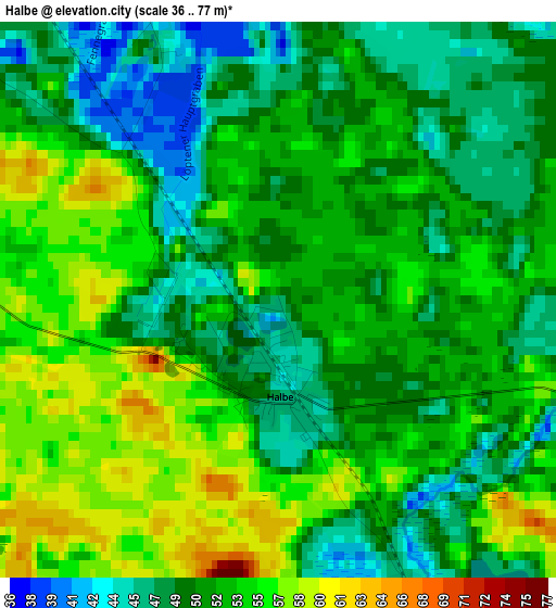
Below is the Elevation map of Halbe, which displays elevation range with different colors. Scale of the first map is from 36 to 77 m (118 to 253 ft) with average elevation of 51.8 meters (=170 ft) [note 1]
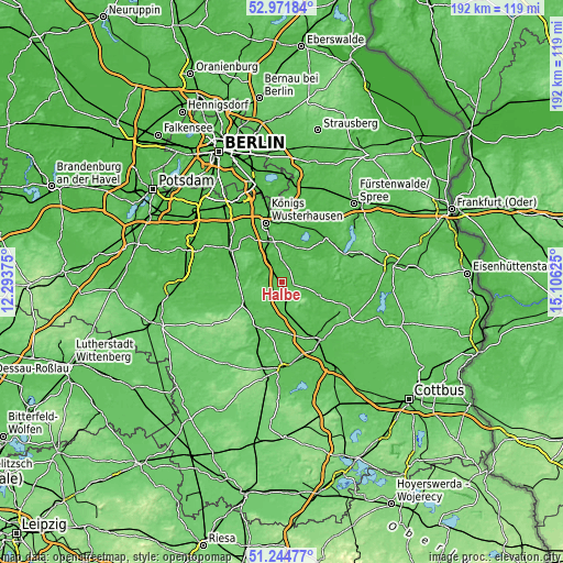
These maps also provides idea of topography and contour of this city, they are displayed at different zoom levels. More info about maps, scale and edge coordinates you can find below images.
| \ | Map #1 | Topo.Map |
| Scale [m] | 36..77 m | × |
| Scale [ft] | 118..253 ft | × |
| Average | 51.8 m = 170 ft | × |
| Width | 6 km = 3.7 mi | 192 km = 119.3 mi |
| Height | 6 km = 3.7 mi | 192 km = 119.3 mi |
| ↑Max Latitude | 52.143647° | 52.97184° |
| Latitude at center | 52.11667° | 52.11667° |
| ↓Min Latitude | 52.089677° | 51.24477° |
| ← Min Longitude | 13.656055° | 12.29375° |
| Longitude center | 13.7° | 13.7° |
| →Max Longitude | 13.743945° | 15.10625° |
Nearby cities:
Cities around Halbe sort by population:
• Königs Wusterhausen elevation 32 m
21 km,  347°
347°
• Zossen 41 m
20.4 km,  302°
302°
• Lübben 53 m
23.7 km,  147°
147°
• Storkow 39 m
22.3 km,  45°
45°
• Mittenwalde 38 m
19.3 km,  325°
325°
• Bestensee 37 m
14.3 km,  342°
342°
• Baruth 60 m
15.7 km,  239°
239°
• Golßen 59 m
17.4 km,  202°
202°
• Groß Köris 37 m
6.1 km, 333°
• Sperenberg 51 m
23 km,  276°
276°
• Teupitz 69 m
5.7 km, 284°
• Wendisch Rietz 42 m
23.8 km,  62°
62°
Multilingual:
 En español:
Halbe elevación 50 m.
 En France:
Halbe élévation 50 m.


Sources and notes:
- [note 1] Map square and city borders are not equal. Map elevation data is calculated only from area inside that square.
- [src 1] Elevation data from geonames database provided with same terms of usage.
- [src 2] The elevation map of Halbe is generated using elevation data from NASA's 3 arcsec (90m) resolution SRTM data.
- [src 3] Base (background) map © OpenStreetMap contributors tiles are generated by Geofabrik and OpenTopoMap.
Copyright & License:
This Halbe Elevation Map is licensed under CC BY-SA. You may reuse any part from this page, if you give a proper credit by linking to this URL:
 More info on terms of use page.