Happurg elevation
Happurg (Bavaria, Regierungsbezirk Mittelfranken), Germany elevation is 354 meters and Happurg elevation in feet is 1161 ft above sea level [src 1]. Happurg is a seat of a fourth-order administrative division (feature code) with elevation that is 96 meters (315 ft) bigger than average city elevation in Germany.
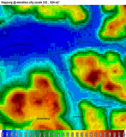
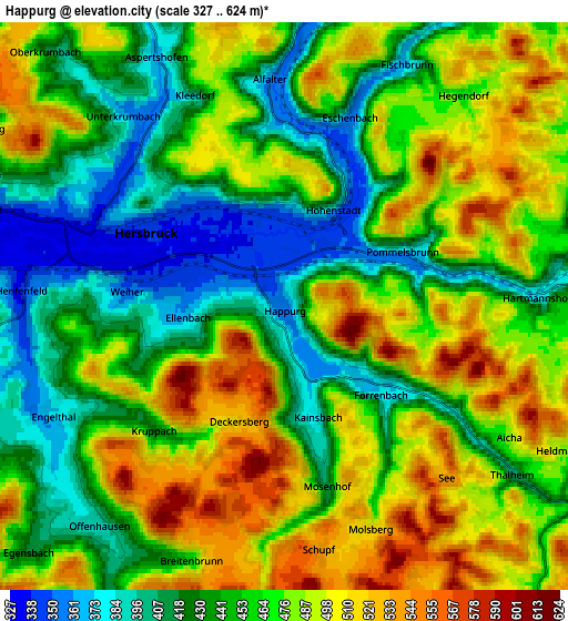
Below is the Elevation map of Happurg, which displays elevation range with different colors. Scale of the first map is from 332 to 624 m (1089 to 2047 ft) with average elevation of 437.5 meters (=1435 ft) [note 1]
These maps also provides idea of topography and contour of this city, they are displayed at different zoom levels. More info about maps, scale and edge coordinates you can find below images.
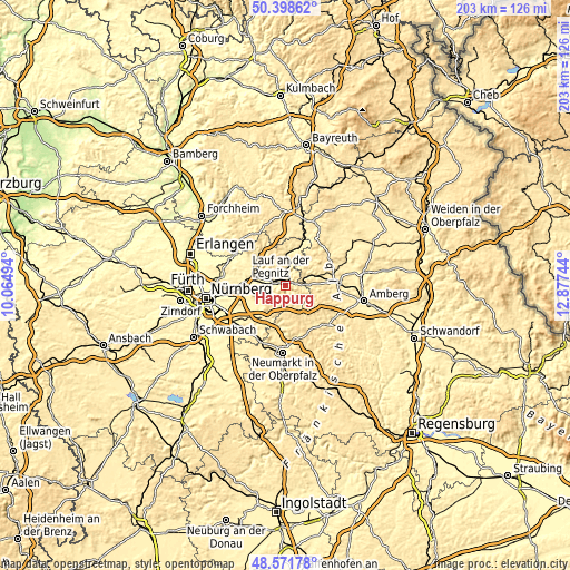
| \ | Map #1 | Map #2 | Topo.Map |
| Scale [m] | 332..624 m | 327..624 m | × |
| Scale [ft] | 1089..2047 ft | 1073..2047 ft | × |
| Average | 437.5 m = 1435 ft | 462.5 m = 1517 ft | × |
| Width | 6.35 km = 3.9 mi | 12.7 km = 7.9 mi | 203.1 km = 126.2 mi |
| Height | 6.35 km = 3.9 mi | 12.7 km = 7.9 mi | 203.1 km = 126.2 mi |
| ↑Max Latitude | 49.522256° | 49.550774° | 50.39862° |
| Latitude at center | 49.49372° | 49.49372° | 49.49372° |
| ↓Min Latitude | 49.465168° | 49.436599° | 48.57178° |
| ← Min Longitude | 11.427245° | 11.383299° | 10.06494° |
| Longitude center | 11.47119° | 11.47119° | 11.47119° |
| →Max Longitude | 11.515135° | 11.559081° | 12.87744° |
Nearby cities:
Cities around Happurg sort by population:
• Hersbruck elevation 340 m
3.4 km,  303°
303°
• Pommelsbrunn 371 m
3.1 km,  67°
67°
• Reichenschwand 342 m
7.5 km,  287°
287°
• Kirchensittenbach 383 m
7.8 km,  332°
332°
• Henfenfeld 341 m
5.8 km,  275°
275°
• Vorra 365 m
7.2 km,  13°
13°
• Offenhausen 389 m
6.4 km,  220°
220°
• Etzelwang 432 m
9.1 km, 65°
• Hirschbach 448 m
7.7 km,  35°
35°
• Weigendorf 406 m
7.1 km,  86°
86°
• Alfeld 481 m
8.8 km,  139°
139°
• Engelthal 373 m
5.7 km,  244°
244°
Multilingual:
 En español:
Happurg elevación 354 m.
 En France:
Happurg élévation 354 m.


Sources and notes:
- [note 1] Map square and city borders are not equal. Map elevation data is calculated only from area inside that square.
- [src 1] Elevation data from geonames database provided with same terms of usage.
- [src 2] The elevation map of Happurg is generated using elevation data from NASA's 3 arcsec (90m) resolution SRTM data.
- [src 3] Base (background) map © OpenStreetMap contributors tiles are generated by Geofabrik and OpenTopoMap.
Copyright & License:
This Happurg Elevation Map is licensed under CC BY-SA. You may reuse any part from this page, if you give a proper credit by linking to this URL:
 More info on terms of use page.