Vorra elevation
Vorra (Bavaria, Regierungsbezirk Mittelfranken), Germany elevation is 365 meters and Vorra elevation in feet is 1198 ft above sea level [src 1]. Vorra is a seat of a fourth-order administrative division (feature code) with elevation that is 107 meters (351 ft) bigger than average city elevation in Germany.
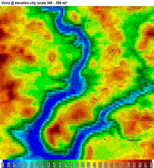
Below is the Elevation map of Vorra, which displays elevation range with different colors. Scale of the first map is from 349 to 580 m (1145 to 1903 ft) with average elevation of 465.4 meters (=1527 ft) [note 1]
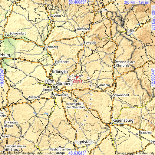
These maps also provides idea of topography and contour of this city, they are displayed at different zoom levels. More info about maps, scale and edge coordinates you can find below images.
| \ | Map #1 | Topo.Map |
| Scale [m] | 349..580 m | × |
| Scale [ft] | 1145..1903 ft | × |
| Average | 465.4 m = 1527 ft | × |
| Width | 6.34 km = 3.9 mi | 202.9 km = 126.1 mi |
| Height | 6.34 km = 3.9 mi | 202.8 km = 126 mi |
| ↑Max Latitude | 49.585679° | 50.46089° |
| Latitude at center | 49.55718° | 49.55718° |
| ↓Min Latitude | 49.528665° | 48.63643° |
| ← Min Longitude | 11.450245° | 10.08794° |
| Longitude center | 11.49419° | 11.49419° |
| →Max Longitude | 11.538135° | 12.90044° |
Nearby cities:
Cities around Vorra sort by population:
• Hersbruck elevation 340 m
6.9 km,  221°
221°
• Pommelsbrunn 371 m
6 km,  168°
168°
• Happurg 354 m
7.2 km,  193°
193°
• Neuhaus an der Pegnitz 400 m
8.9 km,  27°
27°
• Reichenschwand 342 m
10 km,  241°
241°
• Kirchensittenbach 383 m
5.2 km,  268°
268°
• Henfenfeld 341 m
9.9 km,  228°
228°
• Velden 388 m
6.4 km,  10°
10°
• Etzelwang 432 m
7.4 km,  116°
116°
• Hartenstein 451 m
5 km,  18°
18°
• Hirschbach 448 m
2.9 km,  105°
105°
• Weigendorf 406 m
8.5 km,  140°
140°
Multilingual:
 En español:
Vorra elevación 365 m.
 En France:
Vorra élévation 365 m.


Sources and notes:
- [note 1] Map square and city borders are not equal. Map elevation data is calculated only from area inside that square.
- [src 1] Elevation data from geonames database provided with same terms of usage.
- [src 2] The elevation map of Vorra is generated using elevation data from NASA's 3 arcsec (90m) resolution SRTM data.
- [src 3] Base (background) map © OpenStreetMap contributors tiles are generated by Geofabrik and OpenTopoMap.
Copyright & License:
This Vorra Elevation Map is licensed under CC BY-SA. You may reuse any part from this page, if you give a proper credit by linking to this URL:
 More info on terms of use page.