Harthausen elevation
Harthausen (Rheinland-Pfalz), Germany elevation is 110 meters and Harthausen elevation in feet is 361 ft above sea level [src 1]. Harthausen is a seat of a fourth-order administrative division (feature code) with elevation that is 148 meters (486 ft) smaller than average city elevation in Germany.
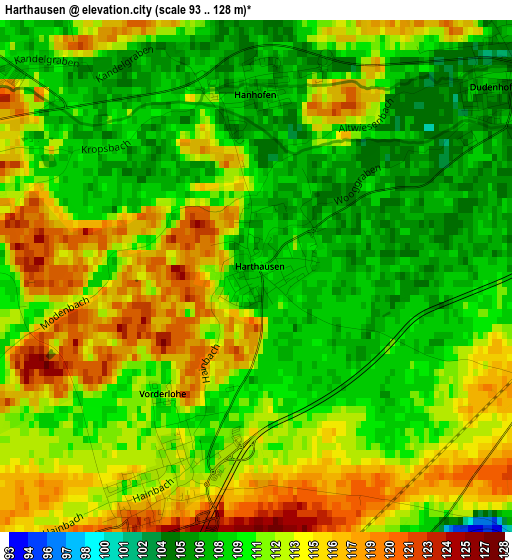
Below is the Elevation map of Harthausen, which displays elevation range with different colors. Scale of the first map is from 93 to 128 m (305 to 420 ft) with average elevation of 111.4 meters (=365 ft) [note 1]
These maps also provides idea of topography and contour of this city, they are displayed at different zoom levels. More info about maps, scale and edge coordinates you can find below images.
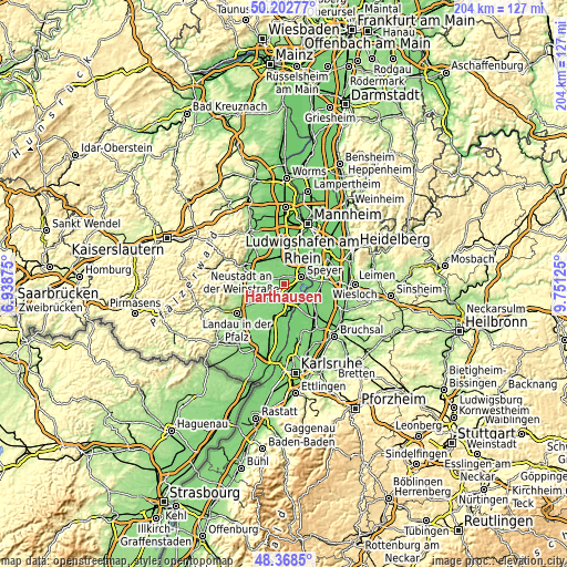
| \ | Map #1 | Topo.Map |
| Scale [m] | 93..128 m | × |
| Scale [ft] | 305..420 ft | × |
| Average | 111.4 m = 365 ft | × |
| Width | 6.37 km = 4 mi | 204 km = 126.8 mi |
| Height | 6.37 km = 4 mi | 203.9 km = 126.7 mi |
| ↑Max Latitude | 49.322822° | 50.20277° |
| Latitude at center | 49.29417° | 49.29417° |
| ↓Min Latitude | 49.265502° | 48.3685° |
| ← Min Longitude | 8.301055° | 6.93875° |
| Longitude center | 8.345° | 8.345° |
| →Max Longitude | 8.388945° | 9.75125° |
Nearby cities:
Cities around Harthausen sort by population:
• Speyer elevation 111 m
6.9 km,  64°
64°
• Germersheim 99 m
8 km,  170°
170°
• Oberhausen-Rheinhausen 96 m
9.5 km,  103°
103°
• Dudenhofen 105 m
4.2 km,  49°
49°
• Lingenfeld 111 m
4.5 km,  185°
185°
• Lustadt 119 m
7.5 km,  223°
223°
• Schwegenheim 115 m
2.9 km,  203°
203°
• Hanhofen 107 m
2.5 km,  353°
353°
• Westheim 114 m
5.5 km, 196°
• Weingarten 126 m
5.8 km,  227°
227°
• Gommersheim 115 m
5.8 km,  266°
266°
• Freisbach 117 m
5.9 km,  244°
244°
Multilingual:
 En español:
Harthausen elevación 110 m.
 En France:
Harthausen élévation 110 m.
 Auf Deutsch:
Harthausen höhe über dem Meeresspiegel ist 110 m.

Sources and notes:
- [note 1] Map square and city borders are not equal. Map elevation data is calculated only from area inside that square.
- [src 1] Elevation data from geonames database provided with same terms of usage.
- [src 2] The elevation map of Harthausen is generated using elevation data from NASA's 3 arcsec (90m) resolution SRTM data.
- [src 3] Base (background) map © OpenStreetMap contributors tiles are generated by Geofabrik and OpenTopoMap.
Copyright & License:
This Harthausen Elevation Map is licensed under CC BY-SA. You may reuse any part from this page, if you give a proper credit by linking to this URL:
 More info on terms of use page.