Hattenhofen elevation
Hattenhofen (Bavaria, Upper Bavaria), Germany elevation is 554 meters and Hattenhofen elevation in feet is 1818 ft above sea level [src 1]. Hattenhofen is a seat of a fourth-order administrative division (feature code) with elevation that is 296 meters (971 ft) bigger than average city elevation in Germany.
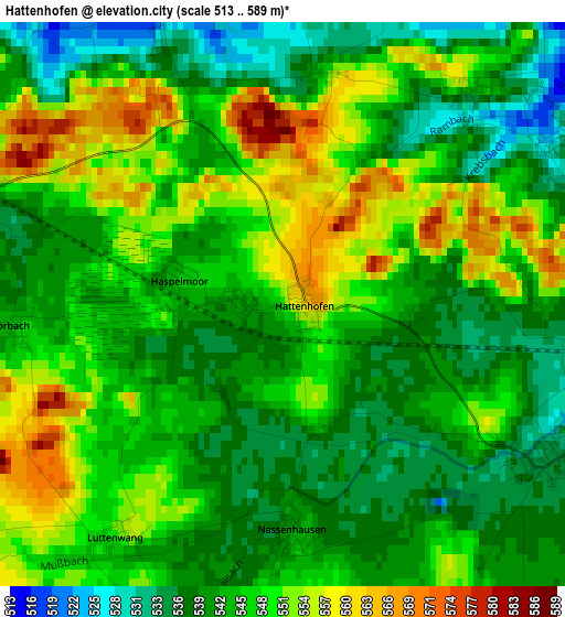
Below is the Elevation map of Hattenhofen, which displays elevation range with different colors. Scale of the first map is from 513 to 589 m (1683 to 1932 ft) with average elevation of 545.5 meters (=1790 ft) [note 1]
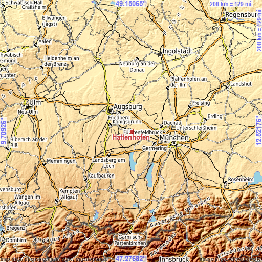
These maps also provides idea of topography and contour of this city, they are displayed at different zoom levels. More info about maps, scale and edge coordinates you can find below images.
| \ | Map #1 | Topo.Map |
| Scale [m] | 513..589 m | × |
| Scale [ft] | 1683..1932 ft | × |
| Average | 545.5 m = 1790 ft | × |
| Width | 6.51 km = 4 mi | 208.4 km = 129.5 mi |
| Height | 6.51 km = 4 mi | 208.3 km = 129.4 mi |
| ↑Max Latitude | 48.25158° | 49.15065° |
| Latitude at center | 48.22231° | 48.22231° |
| ↓Min Latitude | 48.193023° | 47.27682° |
| ← Min Longitude | 11.071565° | 9.70926° |
| Longitude center | 11.11551° | 11.11551° |
| →Max Longitude | 11.159455° | 12.52176° |
Nearby cities:
Cities around Hattenhofen sort by population:
• Mering elevation 511 m
10.8 km,  296°
296°
• Mammendorf 536 m
3.9 km,  113°
113°
• Moorenweis 567 m
7.9 km,  200°
200°
• Egenhofen 509 m
7.8 km,  29°
29°
• Merching 529 m
10 km,  285°
285°
• Althegnenberg 535 m
3.8 km, 288°
• Mittelstetten 531 m
3.3 km,  339°
339°
• Brunnen 528 m
10.6 km,  274°
274°
• Adelshofen 564 m
4.3 km,  178°
178°
• Jesenwang 562 m
6.3 km,  167°
167°
• Oberschweinbach 526 m
3.5 km,  59°
59°
• Landsberied 556 m
7.3 km,  148°
148°
Multilingual:
 En español:
Hattenhofen elevación 554 m.
 En France:
Hattenhofen élévation 554 m.
 Auf Deutsch:
Hattenhofen höhe über dem Meeresspiegel ist 554 m.

Sources and notes:
- [note 1] Map square and city borders are not equal. Map elevation data is calculated only from area inside that square.
- [src 1] Elevation data from geonames database provided with same terms of usage.
- [src 2] The elevation map of Hattenhofen is generated using elevation data from NASA's 3 arcsec (90m) resolution SRTM data.
- [src 3] Base (background) map © OpenStreetMap contributors tiles are generated by Geofabrik and OpenTopoMap.
Copyright & License:
This Hattenhofen Elevation Map is licensed under CC BY-SA. You may reuse any part from this page, if you give a proper credit by linking to this URL:
 More info on terms of use page.