Merching elevation
Merching (Bavaria, Swabia), Germany elevation is 529 meters and Merching elevation in feet is 1736 ft above sea level [src 1]. Merching is a seat of a fourth-order administrative division (feature code) with elevation that is 271 meters (889 ft) bigger than average city elevation in Germany.
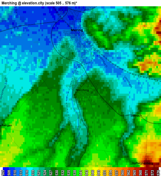
Below is the Elevation map of Merching, which displays elevation range with different colors. Scale of the first map is from 505 to 576 m (1657 to 1890 ft) with average elevation of 526.8 meters (=1728 ft) [note 1]
These maps also provides idea of topography and contour of this city, they are displayed at different zoom levels. More info about maps, scale and edge coordinates you can find below images.
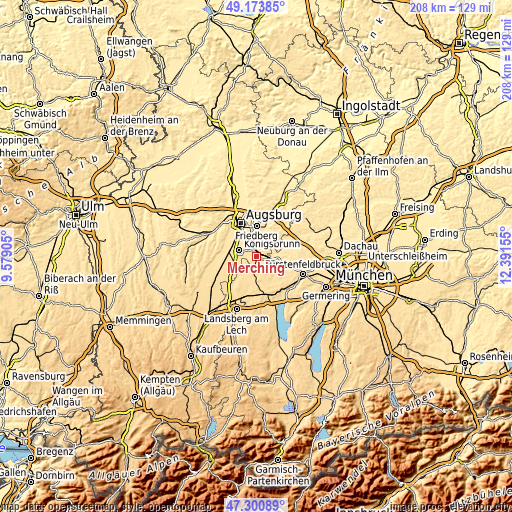
| \ | Map #1 | Topo.Map |
| Scale [m] | 505..576 m | × |
| Scale [ft] | 1657..1890 ft | × |
| Average | 526.8 m = 1728 ft | × |
| Width | 6.51 km = 4 mi | 208.3 km = 129.4 mi |
| Height | 6.51 km = 4 mi | 208.2 km = 129.4 mi |
| ↑Max Latitude | 48.275196° | 49.17385° |
| Latitude at center | 48.24594° | 48.24594° |
| ↓Min Latitude | 48.216667° | 47.30089° |
| ← Min Longitude | 10.941355° | 9.57905° |
| Longitude center | 10.9853° | 10.9853° |
| →Max Longitude | 11.029245° | 12.39155° |
Nearby cities:
Cities around Merching sort by population:
• Königsbrunn elevation 516 m
7.6 km,  295°
295°
• Mering 511 m
2.2 km,  358°
358°
• Kissing 501 m
6.5 km,  350°
350°
• Prittriching 540 m
6.6 km,  220°
220°
• Egling 544 m
6.7 km,  185°
185°
• Althegnenberg 535 m
6.2 km,  103°
103°
• Oberottmarshausen 533 m
9.5 km,  264°
264°
• Mittelstetten 531 m
8.5 km,  86°
86°
• Brunnen 528 m
2 km,  205°
205°
• Kleinaitingen 537 m
9.1 km,  250°
250°
• Hattenhofen 554 m
10 km,  105°
105°
• Schmiechen 537 m
3.5 km,  202°
202°
Multilingual:
 En español:
Merching elevación 529 m.
 En France:
Merching élévation 529 m.
 Auf Deutsch:
Merching höhe über dem Meeresspiegel ist 529 m.

Sources and notes:
- [note 1] Map square and city borders are not equal. Map elevation data is calculated only from area inside that square.
- [src 1] Elevation data from geonames database provided with same terms of usage.
- [src 2] The elevation map of Merching is generated using elevation data from NASA's 3 arcsec (90m) resolution SRTM data.
- [src 3] Base (background) map © OpenStreetMap contributors tiles are generated by Geofabrik and OpenTopoMap.
Copyright & License:
This Merching Elevation Map is licensed under CC BY-SA. You may reuse any part from this page, if you give a proper credit by linking to this URL:
 More info on terms of use page.