Hillerse elevation
Hillerse (Lower Saxony), Germany elevation is 139 meters and Hillerse elevation in feet is 456 ft above sea level [src 1]. Hillerse is a populated place (feature code) with elevation that is 119 meters (390 ft) smaller than average city elevation in Germany.
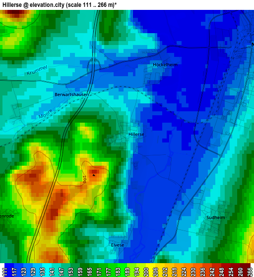
Below is the Elevation map of Hillerse, which displays elevation range with different colors. Scale of the first map is from 111 to 266 m (364 to 873 ft) with average elevation of 147.5 meters (=484 ft) [note 1]
These maps also provides idea of topography and contour of this city, they are displayed at different zoom levels. More info about maps, scale and edge coordinates you can find below images.
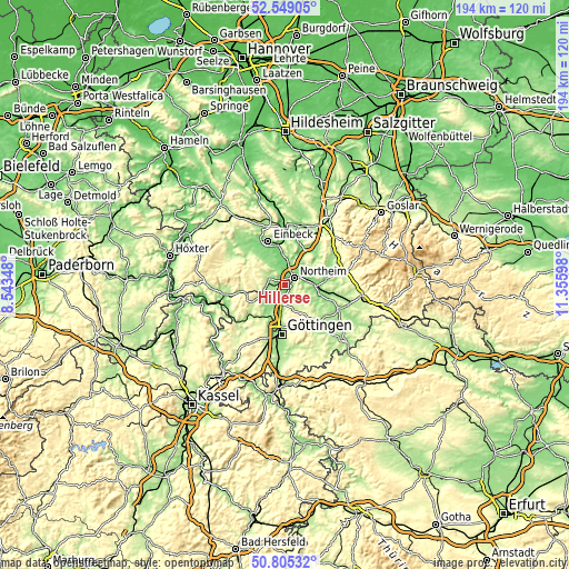
| \ | Map #1 | Topo.Map |
| Scale [m] | 111..266 m | × |
| Scale [ft] | 364..873 ft | × |
| Average | 147.5 m = 484 ft | × |
| Width | 6.06 km = 3.8 mi | 193.9 km = 120.5 mi |
| Height | 6.06 km = 3.8 mi | 193.9 km = 120.5 mi |
| ↑Max Latitude | 51.712817° | 52.54905° |
| Latitude at center | 51.68558° | 51.68558° |
| ↓Min Latitude | 51.658327° | 50.80532° |
| ← Min Longitude | 9.905785° | 8.54348° |
| Longitude center | 9.94973° | 9.94973° |
| →Max Longitude | 9.993675° | 11.35598° |
Nearby cities:
Cities around Hillerse sort by population:
• Northeim elevation 127 m
4.2 km,  55°
55°
• Einbeck 115 m
15.9 km,  339°
339°
• Bovenden 142 m
11 km,  189°
189°
• Hardegsen 184 m
9 km,  245°
245°
• Nörten-Hardenberg 135 m
6.4 km, 188°
• Katlenburg-Lindau 137 m
10.4 km,  91°
91°
• Moringen 179 m
5.6 km,  285°
285°
• Kalefeld 129 m
14 km,  24°
24°
• Bilshausen 156 m
15.7 km,  113°
113°
• Wulften 158 m
15.7 km,  100°
100°
• Waake 249 m
16.2 km,  152°
152°
• Krebeck 218 m
16.2 km,  134°
134°
Multilingual:
 En español:
Hillerse elevación 139 m.
 En France:
Hillerse élévation 139 m.
 Auf Deutsch:
Hillerse höhe über dem Meeresspiegel ist 139 m.

Sources and notes:
- [note 1] Map square and city borders are not equal. Map elevation data is calculated only from area inside that square.
- [src 1] Elevation data from geonames database provided with same terms of usage.
- [src 2] The elevation map of Hillerse is generated using elevation data from NASA's 3 arcsec (90m) resolution SRTM data.
- [src 3] Base (background) map © OpenStreetMap contributors tiles are generated by Geofabrik and OpenTopoMap.
Copyright & License:
This Hillerse Elevation Map is licensed under CC BY-SA. You may reuse any part from this page, if you give a proper credit by linking to this URL:
 More info on terms of use page.