Hohenpeißenberg elevation
Hohenpeißenberg (Bavaria, Upper Bavaria), Germany elevation is 771 meters and Hohenpeißenberg elevation in feet is 2530 ft above sea level [src 1]. Hohenpeißenberg is a seat of a fourth-order administrative division (feature code) with elevation that is 513 meters (1683 ft) bigger than average city elevation in Germany.
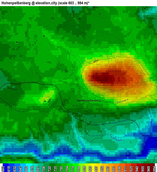
Below is the Elevation map of Hohenpeißenberg, which displays elevation range with different colors. Scale of the first map is from 603 to 984 m (1978 to 3228 ft) with average elevation of 743.9 meters (=2441 ft) [note 1]
These maps also provides idea of topography and contour of this city, they are displayed at different zoom levels. More info about maps, scale and edge coordinates you can find below images.
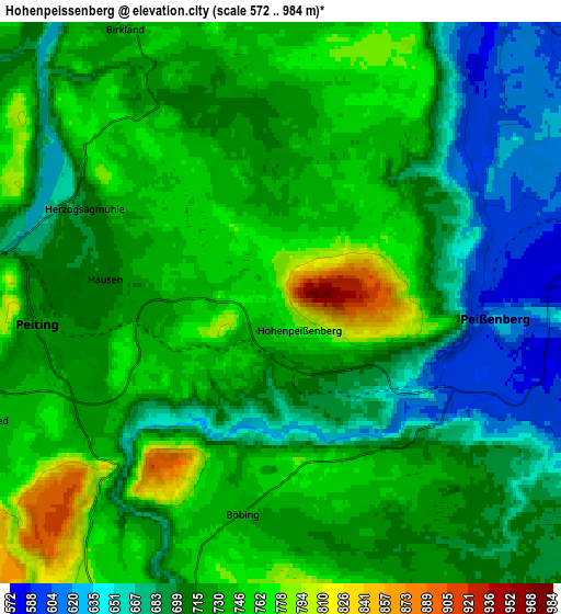
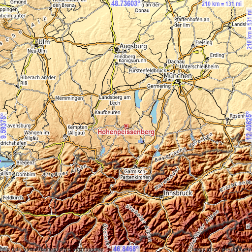
| \ | Map #1 | Map #2 | Topo.Map |
| Scale [m] | 603..984 m | 572..984 m | × |
| Scale [ft] | 1978..3228 ft | 1877..3228 ft | × |
| Average | 743.9 m = 2441 ft | 718.4 m = 2357 ft | × |
| Width | 6.56 km = 4.1 mi | 13.13 km = 8.2 mi | 210.1 km = 130.5 mi |
| Height | 6.56 km = 4.1 mi | 13.13 km = 8.2 mi | 210 km = 130.5 mi |
| ↑Max Latitude | 47.829511° | 47.859004° | 48.73603° |
| Latitude at center | 47.8° | 47.8° | 47.8° |
| ↓Min Latitude | 47.770473° | 47.740929° | 46.8468° |
| ← Min Longitude | 10.956055° | 10.912109° | 9.59375° |
| Longitude center | 11° | 11° | 11° |
| →Max Longitude | 11.043945° | 11.087891° | 12.40625° |
Nearby cities:
Cities around Hohenpeißenberg sort by population:
• Peißenberg elevation 582 m
5.2 km,  84°
84°
• Schongau 713 m
7.8 km,  280°
280°
• Peiting 719 m
5.3 km,  264°
264°
• Altenstadt 723 m
9.7 km,  285°
285°
• Polling 569 m
10 km, 82°
• Oberhausen 588 m
10.1 km,  100°
100°
• Wessobrunn 698 m
8.4 km,  12°
12°
• Rottenbuch 768 m
7.8 km,  198°
198°
• Böbing 742 m
5 km,  189°
189°
• Hohenfurch 702 m
9.3 km,  306°
306°
• Wildsteig 866 m
11.9 km, 203°
• Apfeldorf 665 m
12.2 km,  335°
335°
Multilingual:
 En español:
Hohenpeißenberg elevación 771 m.
 En France:
Hohenpeißenberg élévation 771 m.
 Auf Deutsch:
Hohenpeißenberg höhe über dem Meeresspiegel ist 771 m.

Sources and notes:
- [note 1] Map square and city borders are not equal. Map elevation data is calculated only from area inside that square.
- [src 1] Elevation data from geonames database provided with same terms of usage.
- [src 2] The elevation map of Hohenpeißenberg is generated using elevation data from NASA's 3 arcsec (90m) resolution SRTM data.
- [src 3] Base (background) map © OpenStreetMap contributors tiles are generated by Geofabrik and OpenTopoMap.
Copyright & License:
This Hohenpeißenberg Elevation Map is licensed under CC BY-SA. You may reuse any part from this page, if you give a proper credit by linking to this URL:
 More info on terms of use page.