Peiting elevation
Peiting (Bavaria, Upper Bavaria), Germany elevation is 719 meters and Peiting elevation in feet is 2359 ft above sea level [src 1]. Peiting is a populated place (feature code) with elevation that is 461 meters (1512 ft) bigger than average city elevation in Germany.
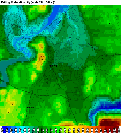
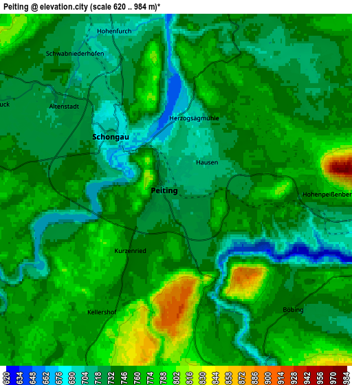
Below is the Elevation map of Peiting, which displays elevation range with different colors. Scale of the first map is from 634 to 902 m (2080 to 2959 ft) with average elevation of 729.4 meters (=2393 ft) [note 1]
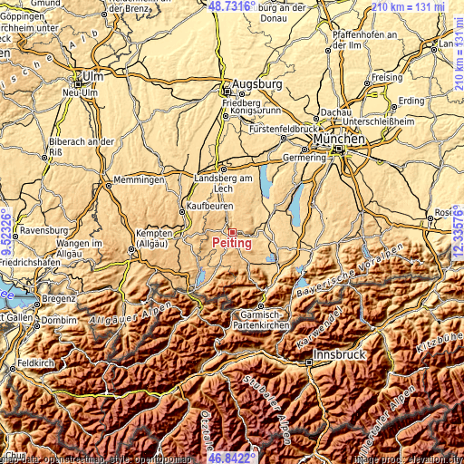
These maps also provides idea of topography and contour of this city, they are displayed at different zoom levels. More info about maps, scale and edge coordinates you can find below images.
| \ | Map #1 | Map #2 | Topo.Map |
| Scale [m] | 634..902 m | 620..984 m | × |
| Scale [ft] | 2080..2959 ft | 2034..3228 ft | × |
| Average | 729.4 m = 2393 ft | 744 m = 2441 ft | × |
| Width | 6.56 km = 4.1 mi | 13.13 km = 8.2 mi | 210.1 km = 130.5 mi |
| Height | 6.56 km = 4.1 mi | 13.13 km = 8.2 mi | 210.1 km = 130.5 mi |
| ↑Max Latitude | 47.825003° | 47.8545° | 48.7316° |
| Latitude at center | 47.79549° | 47.79549° | 47.79549° |
| ↓Min Latitude | 47.76596° | 47.736413° | 46.8422° |
| ← Min Longitude | 10.885565° | 10.841619° | 9.52326° |
| Longitude center | 10.92951° | 10.92951° | 10.92951° |
| →Max Longitude | 10.973455° | 11.017401° | 12.33576° |
Nearby cities:
Cities around Peiting sort by population:
• Peißenberg elevation 582 m
10.5 km,  84°
84°
• Schongau 713 m
3.1 km,  307°
307°
• Hohenpeißenberg 771 m
5.3 km, 84°
• Altenstadt 723 m
5.1 km, 307°
• Wessobrunn 698 m
11.3 km,  39°
39°
• Rottenbuch 768 m
7.4 km,  158°
158°
• Böbing 742 m
6.3 km,  135°
135°
• Burggen 747 m
8.6 km,  256°
256°
• Hohenfurch 702 m
6.4 km,  340°
340°
• Schwabsoien 735 m
8.3 km,  300°
300°
• Wildsteig 866 m
10.5 km,  176°
176°
• Apfeldorf 665 m
11.6 km,  1°
1°
Multilingual:
 En español:
Peiting elevación 719 m.
 En France:
Peiting élévation 719 m.


Sources and notes:
- [note 1] Map square and city borders are not equal. Map elevation data is calculated only from area inside that square.
- [src 1] Elevation data from geonames database provided with same terms of usage.
- [src 2] The elevation map of Peiting is generated using elevation data from NASA's 3 arcsec (90m) resolution SRTM data.
- [src 3] Base (background) map © OpenStreetMap contributors tiles are generated by Geofabrik and OpenTopoMap.
Copyright & License:
This Peiting Elevation Map is licensed under CC BY-SA. You may reuse any part from this page, if you give a proper credit by linking to this URL:
 More info on terms of use page.