Hornhausen elevation
Hornhausen (Saxony-Anhalt), Germany elevation is 85 meters and Hornhausen elevation in feet is 279 ft above sea level [src 1]. Hornhausen is a populated place (feature code) with elevation that is 173 meters (568 ft) smaller than average city elevation in Germany.
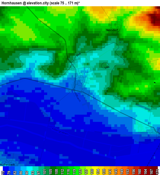
Below is the Elevation map of Hornhausen, which displays elevation range with different colors. Scale of the first map is from 75 to 171 m (246 to 561 ft) with average elevation of 96.7 meters (=317 ft) [note 1]
These maps also provides idea of topography and contour of this city, they are displayed at different zoom levels. More info about maps, scale and edge coordinates you can find below images.
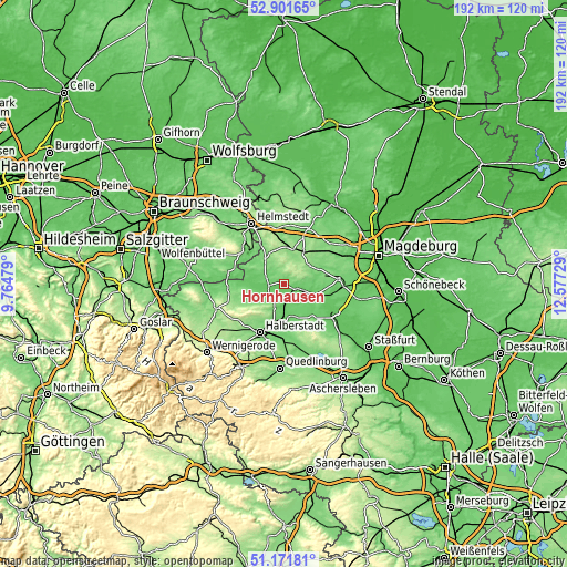
| \ | Map #1 | Topo.Map |
| Scale [m] | 75..171 m | × |
| Scale [ft] | 246..561 ft | × |
| Average | 96.7 m = 317 ft | × |
| Width | 6.01 km = 3.7 mi | 192.3 km = 119.5 mi |
| Height | 6.01 km = 3.7 mi | 192.3 km = 119.5 mi |
| ↑Max Latitude | 52.07212° | 52.90165° |
| Latitude at center | 52.0451° | 52.0451° |
| ↓Min Latitude | 52.018064° | 51.17181° |
| ← Min Longitude | 11.127095° | 9.76479° |
| Longitude center | 11.17104° | 11.17104° |
| →Max Longitude | 11.214985° | 12.57729° |
Nearby cities:
Cities around Hornhausen sort by population:
• Oschersleben elevation 82 m
4.3 km,  112°
112°
• Gröningen 92 m
12.4 km,  165°
165°
• Klein Wanzleben 110 m
13.6 km,  78°
78°
• Hötensleben 107 m
13.1 km,  309°
309°
• Schwanebeck 112 m
9.2 km,  200°
200°
• Eilsleben 134 m
11.7 km,  13°
13°
• Ausleben 111 m
6.5 km,  321°
321°
• Hadmersleben 81 m
10.7 km,  122°
122°
• Seehausen 140 m
10.4 km,  52°
52°
• Völpke 128 m
11.5 km,  334°
334°
• Ummendorf 142 m
12.4 km,  3°
3°
• Groß Quenstedt 101 m
13 km, 196°
Multilingual:
 En español:
Hornhausen elevación 85 m.
 En France:
Hornhausen élévation 85 m.
 Auf Deutsch:
Hornhausen höhe über dem Meeresspiegel ist 85 m.

Sources and notes:
- [note 1] Map square and city borders are not equal. Map elevation data is calculated only from area inside that square.
- [src 1] Elevation data from geonames database provided with same terms of usage.
- [src 2] The elevation map of Hornhausen is generated using elevation data from NASA's 3 arcsec (90m) resolution SRTM data.
- [src 3] Base (background) map © OpenStreetMap contributors tiles are generated by Geofabrik and OpenTopoMap.
Copyright & License:
This Hornhausen Elevation Map is licensed under CC BY-SA. You may reuse any part from this page, if you give a proper credit by linking to this URL:
 More info on terms of use page.