Hundeshagen elevation
Hundeshagen (Thuringia), Germany elevation is 270 meters and Hundeshagen elevation in feet is 886 ft above sea level [src 1]. Hundeshagen is a seat of a fourth-order administrative division (feature code) with elevation that is 12 meters (39 ft) bigger than average city elevation in Germany.
Below is the Elevation map of Hundeshagen, which displays elevation range with different colors. Scale of the first map is from 211 to 455 m (692 to 1493 ft) with average elevation of 327.3 meters (=1074 ft) [note 1]
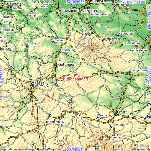
These maps also provides idea of topography and contour of this city, they are displayed at different zoom levels. More info about maps, scale and edge coordinates you can find below images.
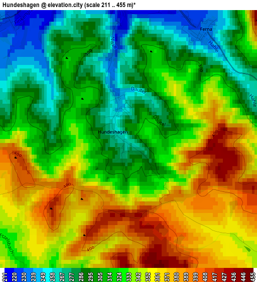
| \ | Map #1 | Topo.Map |
| Scale [m] | 211..455 m | × |
| Scale [ft] | 692..1493 ft | × |
| Average | 327.3 m = 1074 ft | × |
| Width | 6.09 km = 3.8 mi | 195 km = 121.2 mi |
| Height | 6.09 km = 3.8 mi | 194.9 km = 121.1 mi |
| ↑Max Latitude | 51.460718° | 52.30163° |
| Latitude at center | 51.43333° | 51.43333° |
| ↓Min Latitude | 51.405925° | 50.54821° |
| ← Min Longitude | 10.239385° | 8.87708° |
| Longitude center | 10.28333° | 10.28333° |
| →Max Longitude | 10.327275° | 11.68958° |
Nearby cities:
Cities around Hundeshagen sort by population:
• Duderstadt elevation 186 m
9 km,  349°
349°
• Heilbad Heiligenstadt 264 m
11.8 km,  238°
238°
• Leinefelde-Worbis 338 m
5.9 km,  149°
149°
• Worbis 324 m
5.7 km,  104°
104°
• Teistungen 198 m
3.9 km,  342°
342°
• Breitenworbis 299 m
10.3 km, 102°
• Gernrode 289 m
8.9 km,  114°
114°
• Kirchworbis 315 m
8.2 km, 107°
• Berlingerode 226 m
4.1 km,  311°
311°
• Wingerode 301 m
5.7 km,  212°
212°
• Brehme 274 m
8.6 km,  37°
37°
• Geisleden 328 m
10.9 km, 211°
Multilingual:
 En español:
Hundeshagen elevación 270 m.
 En France:
Hundeshagen élévation 270 m.
 Auf Deutsch:
Hundeshagen höhe über dem Meeresspiegel ist 270 m.

Sources and notes:
- [note 1] Map square and city borders are not equal. Map elevation data is calculated only from area inside that square.
- [src 1] Elevation data from geonames database provided with same terms of usage.
- [src 2] The elevation map of Hundeshagen is generated using elevation data from NASA's 3 arcsec (90m) resolution SRTM data.
- [src 3] Base (background) map © OpenStreetMap contributors tiles are generated by Geofabrik and OpenTopoMap.
Copyright & License:
This Hundeshagen Elevation Map is licensed under CC BY-SA. You may reuse any part from this page, if you give a proper credit by linking to this URL:
 More info on terms of use page.