Jüterbog elevation
Jüterbog (Brandenburg), Germany elevation is 72 meters and Jüterbog elevation in feet is 236 ft above sea level [src 1]. Jüterbog is a populated place (feature code) with elevation that is 186 meters (610 ft) smaller than average city elevation in Germany.
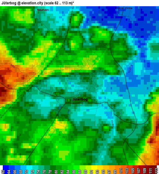
Below is the Elevation map of Jüterbog, which displays elevation range with different colors. Scale of the first map is from 62 to 113 m (203 to 371 ft) with average elevation of 79 meters (=259 ft) [note 1]
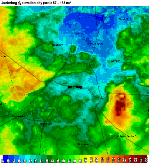
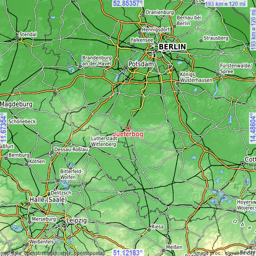
These maps also provides idea of topography and contour of this city, they are displayed at different zoom levels. More info about maps, scale and edge coordinates you can find below images.
| \ | Map #1 | Map #2 | Topo.Map |
| Scale [m] | 62..113 m | 57..133 m | × |
| Scale [ft] | 203..371 ft | 187..436 ft | × |
| Average | 79 m = 259 ft | 84.1 m = 276 ft | × |
| Width | 6.02 km = 3.7 mi | 12.03 km = 7.5 mi | 192.6 km = 119.7 mi |
| Height | 6.02 km = 3.7 mi | 12.03 km = 7.5 mi | 192.5 km = 119.6 mi |
| ↑Max Latitude | 52.02312° | 52.050153° | 52.85357° |
| Latitude at center | 51.99607° | 51.99607° | 51.99607° |
| ↓Min Latitude | 51.969004° | 51.941922° | 51.12183° |
| ← Min Longitude | 13.035845° | 12.991899° | 11.67354° |
| Longitude center | 13.07979° | 13.07979° | 13.07979° |
| →Max Longitude | 13.123735° | 13.167681° | 14.48604° |
Nearby cities:
Cities around Jüterbog sort by population:
• Luckenwalde elevation 52 m
12.1 km,  29°
29°
• Jessen 78 m
24 km,  200°
200°
• Trebbin 41 m
26.5 km,  22°
22°
• Treuenbrietzen 62 m
18.1 km,  308°
308°
• Niedergörsdorf 87 m
6.7 km,  254°
254°
• Zahna 91 m
22.1 km, 245°
• Elster 72 m
25.5 km,  223°
223°
• Sperenberg 51 m
25.3 km,  50°
50°
• Abtsdorf 103 m
27 km,  244°
244°
• Kropstädt 108 m
23.2 km,  260°
260°
• Holzdorf 79 m
24.4 km,  172°
172°
• Seyda 79 m
17.3 km, 222°
Multilingual:
 En español:
Jüterbog elevación 72 m.
 En France:
Jüterbog élévation 72 m.


Sources and notes:
- [note 1] Map square and city borders are not equal. Map elevation data is calculated only from area inside that square.
- [src 1] Elevation data from geonames database provided with same terms of usage.
- [src 2] The elevation map of Jüterbog is generated using elevation data from NASA's 3 arcsec (90m) resolution SRTM data.
- [src 3] Base (background) map © OpenStreetMap contributors tiles are generated by Geofabrik and OpenTopoMap.
Copyright & License:
This Jüterbog Elevation Map is licensed under CC BY-SA. You may reuse any part from this page, if you give a proper credit by linking to this URL:
 More info on terms of use page.