Karlshuld elevation
Karlshuld (Bavaria, Upper Bavaria), Germany elevation is 377 meters and Karlshuld elevation in feet is 1237 ft above sea level [src 1]. Karlshuld is a seat of a fourth-order administrative division (feature code) with elevation that is 119 meters (390 ft) bigger than average city elevation in Germany.
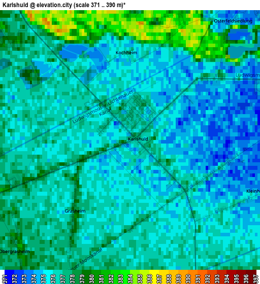
Below is the Elevation map of Karlshuld, which displays elevation range with different colors. Scale of the first map is from 371 to 390 m (1217 to 1280 ft) with average elevation of 376.2 meters (=1234 ft) [note 1]
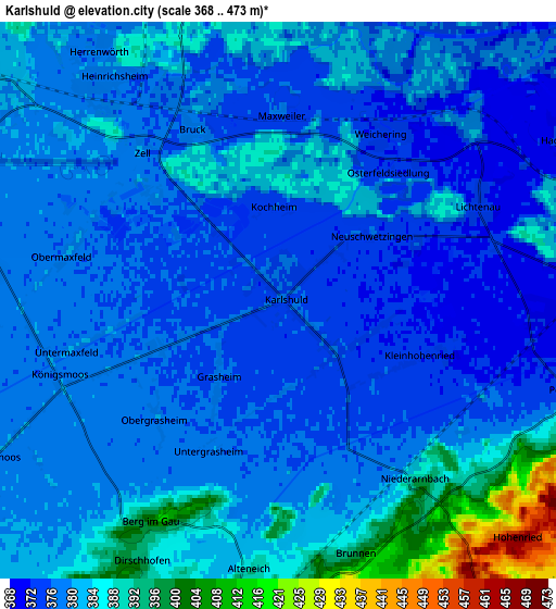
These maps also provides idea of topography and contour of this city, they are displayed at different zoom levels. More info about maps, scale and edge coordinates you can find below images.
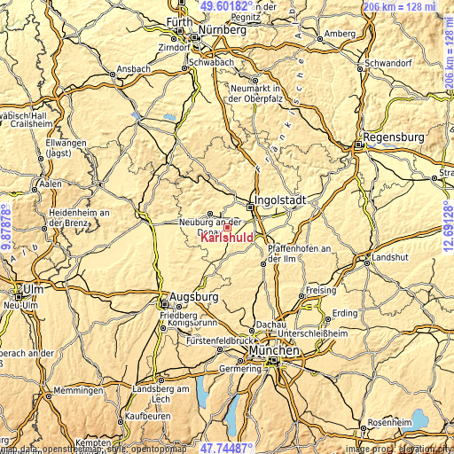
| \ | Map #1 | Map #2 | Topo.Map |
| Scale [m] | 371..390 m | 368..473 m | × |
| Scale [ft] | 1217..1280 ft | 1207..1552 ft | × |
| Average | 376.2 m = 1234 ft | 381.1 m = 1250 ft | × |
| Width | 6.45 km = 4 mi | 12.9 km = 8 mi | 206.5 km = 128.3 mi |
| Height | 6.45 km = 4 mi | 12.9 km = 8 mi | 206.5 km = 128.3 mi |
| ↑Max Latitude | 48.710906° | 48.739895° | 49.60182° |
| Latitude at center | 48.6819° | 48.6819° | 48.6819° |
| ↓Min Latitude | 48.652877° | 48.623838° | 47.74487° |
| ← Min Longitude | 11.241085° | 11.197139° | 9.87878° |
| Longitude center | 11.28503° | 11.28503° | 11.28503° |
| →Max Longitude | 11.328975° | 11.372921° | 12.69128° |
Nearby cities:
Cities around Karlshuld sort by population:
• Ingolstadt elevation 379 m
13.7 km,  47°
47°
• Neuburg an der Donau 381 m
9.1 km,  307°
307°
• Schrobenhausen 414 m
13.6 km,  187°
187°
• Reichertshofen 383 m
13.6 km,  101°
101°
• Baar-Ebenhausen 377 m
13.6 km, 95°
• Karlskron 367 m
9.7 km,  89°
89°
• Oberhausen 421 m
13.5 km,  289°
289°
• Weichering 375 m
4.7 km,  34°
34°
• Waidhofen 407 m
12.3 km,  162°
162°
• Langenmosen 403 m
9.9 km,  212°
212°
• Rohrenfels 392 m
9.5 km,  273°
273°
• Berg im Gau 394 m
6 km, 205°
Multilingual:
 En español:
Karlshuld elevación 377 m.
 En France:
Karlshuld élévation 377 m.
 Auf Deutsch:
Karlshuld höhe über dem Meeresspiegel ist 377 m.

Sources and notes:
- [note 1] Map square and city borders are not equal. Map elevation data is calculated only from area inside that square.
- [src 1] Elevation data from geonames database provided with same terms of usage.
- [src 2] The elevation map of Karlshuld is generated using elevation data from NASA's 3 arcsec (90m) resolution SRTM data.
- [src 3] Base (background) map © OpenStreetMap contributors tiles are generated by Geofabrik and OpenTopoMap.
Copyright & License:
This Karlshuld Elevation Map is licensed under CC BY-SA. You may reuse any part from this page, if you give a proper credit by linking to this URL:
 More info on terms of use page.