Karow elevation
Karow (Berlin), Germany elevation is 55 meters and Karow elevation in feet is 180 ft above sea level [src 1]. Karow is a section of populated place (feature code) with elevation that is 203 meters (666 ft) smaller than average city elevation in Germany.
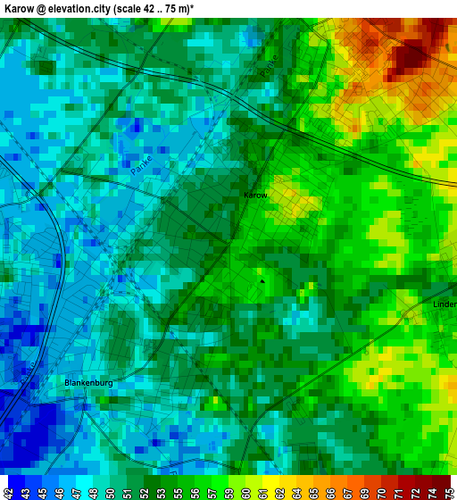
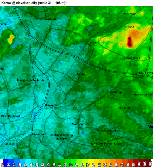
Below is the Elevation map of Karow, which displays elevation range with different colors. Scale of the first map is from 42 to 75 m (138 to 246 ft) with average elevation of 52.5 meters (=172 ft) [note 1]
These maps also provides idea of topography and contour of this city, they are displayed at different zoom levels. More info about maps, scale and edge coordinates you can find below images.
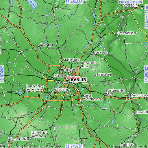
| \ | Map #1 | Map #2 | Topo.Map |
| Scale [m] | 42..75 m | 31..108 m | × |
| Scale [ft] | 138..246 ft | 102..354 ft | × |
| Average | 52.5 m = 172 ft | 54.8 m = 180 ft | × |
| Width | 5.93 km = 3.7 mi | 11.87 km = 7.4 mi | 189.9 km = 118 mi |
| Height | 5.93 km = 3.7 mi | 11.87 km = 7.4 mi | 189.9 km = 118 mi |
| ↑Max Latitude | 52.635718° | 52.662379° | 53.45468° |
| Latitude at center | 52.60904° | 52.60904° | 52.60904° |
| ↓Min Latitude | 52.582346° | 52.555636° | 51.74675° |
| ← Min Longitude | 13.437225° | 13.393279° | 12.07492° |
| Longitude center | 13.48117° | 13.48117° | 13.48117° |
| →Max Longitude | 13.525115° | 13.569061° | 14.88742° |
Nearby cities:
Cities around Karow sort by population:
• Pankow elevation 47 m
6.9 km,  230°
230°
• Neu-Hohenschönhausen 55 m
5.2 km,  155°
155°
• Weißensee 53 m
5.9 km,  189°
189°
• Niederschönhausen 48 m
5.9 km,  243°
243°
• Französisch Buchholz 46 m
3.5 km,  257°
257°
• Buch 57 m
3 km,  20°
20°
• Blankenburg 47 m
2.5 km,  224°
224°
• Heinersdorf 50 m
5.1 km, 215°
• Wartenberg 58 m
4.4 km,  148°
148°
• Blankenfelde 53 m
6.2 km,  279°
279°
• Falkenberg 56 m
6.3 km,  136°
136°
• Stadtrandsiedlung Malchow 47 m
2.9 km,  184°
184°
Multilingual:
 En español:
Karow elevación 55 m.
 En France:
Karow élévation 55 m.


Sources and notes:
- [note 1] Map square and city borders are not equal. Map elevation data is calculated only from area inside that square.
- [src 1] Elevation data from geonames database provided with same terms of usage.
- [src 2] The elevation map of Karow is generated using elevation data from NASA's 3 arcsec (90m) resolution SRTM data.
- [src 3] Base (background) map © OpenStreetMap contributors tiles are generated by Geofabrik and OpenTopoMap.
Copyright & License:
This Karow Elevation Map is licensed under CC BY-SA. You may reuse any part from this page, if you give a proper credit by linking to this URL:
 More info on terms of use page.