Kirchheim bei München elevation
Kirchheim bei München (Bavaria, Upper Bavaria), Germany elevation is 511 meters and Kirchheim bei München elevation in feet is 1677 ft above sea level [src 1]. Kirchheim bei München is a section of populated place (feature code) with elevation that is 253 meters (830 ft) bigger than average city elevation in Germany.
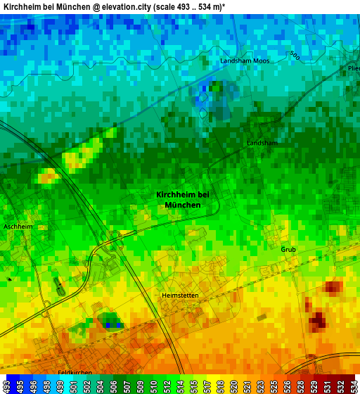
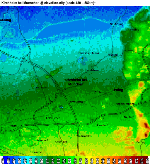
Below is the Elevation map of Kirchheim bei München, which displays elevation range with different colors. Scale of the first map is from 493 to 534 m (1617 to 1752 ft) with average elevation of 510.1 meters (=1674 ft) [note 1]
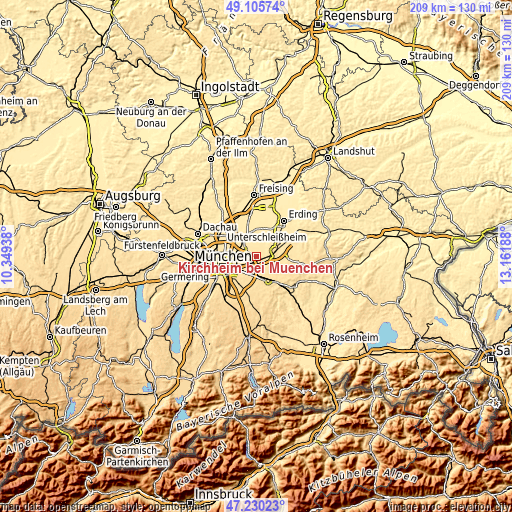
These maps also provides idea of topography and contour of this city, they are displayed at different zoom levels. More info about maps, scale and edge coordinates you can find below images.
| \ | Map #1 | Map #2 | Topo.Map |
| Scale [m] | 493..534 m | 480..580 m | × |
| Scale [ft] | 1617..1752 ft | 1575..1903 ft | × |
| Average | 510.1 m = 1674 ft | 512.5 m = 1681 ft | × |
| Width | 6.52 km = 4.1 mi | 13.03 km = 8.1 mi | 208.5 km = 129.6 mi |
| Height | 6.52 km = 4.1 mi | 13.03 km = 8.1 mi | 208.5 km = 129.6 mi |
| ↑Max Latitude | 48.205856° | 48.235135° | 49.10574° |
| Latitude at center | 48.17656° | 48.17656° | 48.17656° |
| ↓Min Latitude | 48.147247° | 48.117918° | 47.23023° |
| ← Min Longitude | 11.711685° | 11.667739° | 10.34938° |
| Longitude center | 11.75563° | 11.75563° | 11.75563° |
| →Max Longitude | 11.799575° | 11.843521° | 13.16188° |
Nearby cities:
Cities around Kirchheim bei München sort by population:
• Vaterstetten elevation 547 m
8 km,  173°
173°
• Haar 545 m
7.8 km,  195°
195°
• Ismaning 488 m
8.3 km,  319°
319°
• Poing 519 m
4.7 km,  98°
98°
• Markt Schwaben 512 m
8.5 km,  80°
80°
• Unterföhring 505 m
8.5 km,  281°
281°
• Aschheim 515 m
2.9 km,  258°
258°
• Feldkirchen 525 m
3.7 km,  210°
210°
• Pliening 504 m
4 km,  57°
57°
• Finsing 509 m
6.7 km,  49°
49°
• Anzing 518 m
7.8 km,  110°
110°
• Ottenhofen 490 m
10.5 km, 64°
Multilingual:
 En español:
Kirchheim bei München elevación 511 m.
 En France:
Kirchheim bei München élévation 511 m.
 Auf Deutsch:
Kirchheim bei München höhe über dem Meeresspiegel ist 511 m.

Sources and notes:
- [note 1] Map square and city borders are not equal. Map elevation data is calculated only from area inside that square.
- [src 1] Elevation data from geonames database provided with same terms of usage.
- [src 2] The elevation map of Kirchheim bei München is generated using elevation data from NASA's 3 arcsec (90m) resolution SRTM data.
- [src 3] Base (background) map © OpenStreetMap contributors tiles are generated by Geofabrik and OpenTopoMap.
Copyright & License:
This Kirchheim bei München Elevation Map is licensed under CC BY-SA. You may reuse any part from this page, if you give a proper credit by linking to this URL:
 More info on terms of use page.