Konz elevation
Konz (Rheinland-Pfalz), Germany elevation is 136 meters and Konz elevation in feet is 446 ft above sea level [src 1]. Konz is a populated place (feature code) with elevation that is 122 meters (400 ft) smaller than average city elevation in Germany.
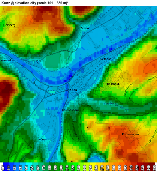
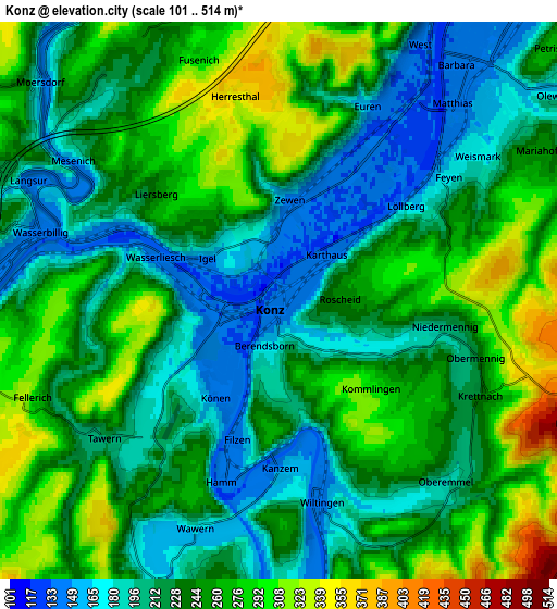
Below is the Elevation map of Konz, which displays elevation range with different colors. Scale of the first map is from 101 to 359 m (331 to 1178 ft) with average elevation of 201.2 meters (=660 ft) [note 1]
These maps also provides idea of topography and contour of this city, they are displayed at different zoom levels. More info about maps, scale and edge coordinates you can find below images.
| \ | Map #1 | Map #2 | Topo.Map |
| Scale [m] | 101..359 m | 101..514 m | × |
| Scale [ft] | 331..1178 ft | 331..1686 ft | × |
| Average | 201.2 m = 660 ft | 237.2 m = 778 ft | × |
| Width | 6.32 km = 3.9 mi | 12.64 km = 7.9 mi | 202.3 km = 125.7 mi |
| Height | 6.32 km = 3.9 mi | 12.64 km = 7.9 mi | 202.3 km = 125.7 mi |
| ↑Max Latitude | 49.728865° | 49.757263° | 50.60149° |
| Latitude at center | 49.70045° | 49.70045° | 49.70045° |
| ↓Min Latitude | 49.672019° | 49.643571° | 48.78238° |
| ← Min Longitude | 6.532575° | 6.488629° | 5.17027° |
| Longitude center | 6.57652° | 6.57652° | 6.57652° |
| →Max Longitude | 6.620465° | 6.664411° | 7.98277° |
Nearby cities:
Cities around Konz sort by population:
• Trier elevation 141 m
7.6 km,  36°
36°
• Trierweiler 283 m
7 km,  350°
350°
• Irsch 230 m
9.2 km,  71°
71°
• Tawern 238 m
5.7 km,  228°
228°
• Wasserliesch 141 m
2.8 km,  286°
286°
• Igel 155 m
1.9 km,  305°
305°
• Langsur 143 m
6.2 km,  295°
295°
• Ayl 173 m
7.7 km,  194°
194°
• Wiltingen 157 m
4.7 km,  165°
165°
• Pluwig 310 m
9.8 km,  96°
96°
• Aach 226 m
9.4 km,  10°
10°
• Pellingen 442 m
7.3 km,  112°
112°
Multilingual:
 En español:
Konz elevación 136 m.
 En France:
Konz élévation 136 m.


Sources and notes:
- [note 1] Map square and city borders are not equal. Map elevation data is calculated only from area inside that square.
- [src 1] Elevation data from geonames database provided with same terms of usage.
- [src 2] The elevation map of Konz is generated using elevation data from NASA's 3 arcsec (90m) resolution SRTM data.
- [src 3] Base (background) map © OpenStreetMap contributors tiles are generated by Geofabrik and OpenTopoMap.
Copyright & License:
This Konz Elevation Map is licensed under CC BY-SA. You may reuse any part from this page, if you give a proper credit by linking to this URL:
 More info on terms of use page.