Trierweiler elevation
Trierweiler (Rheinland-Pfalz), Germany elevation is 283 meters and Trierweiler elevation in feet is 928 ft above sea level [src 1]. Trierweiler is a seat of a fourth-order administrative division (feature code) with elevation that is 25 meters (82 ft) bigger than average city elevation in Germany.
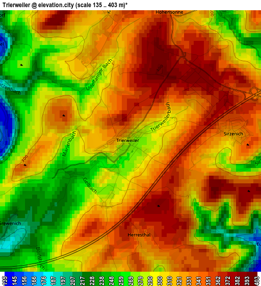
Below is the Elevation map of Trierweiler, which displays elevation range with different colors. Scale of the first map is from 135 to 403 m (443 to 1322 ft) with average elevation of 308.4 meters (=1012 ft) [note 1]
These maps also provides idea of topography and contour of this city, they are displayed at different zoom levels. More info about maps, scale and edge coordinates you can find below images.
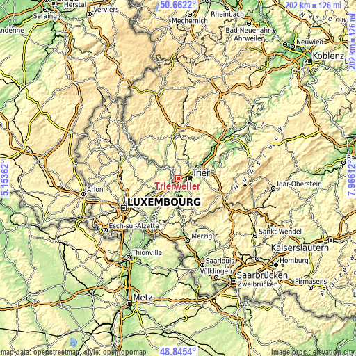
| \ | Map #1 | Topo.Map |
| Scale [m] | 135..403 m | × |
| Scale [ft] | 443..1322 ft | × |
| Average | 308.4 m = 1012 ft | × |
| Width | 6.31 km = 3.9 mi | 202 km = 125.5 mi |
| Height | 6.31 km = 3.9 mi | 202 km = 125.5 mi |
| ↑Max Latitude | 49.790689° | 50.6622° |
| Latitude at center | 49.76231° | 49.76231° |
| ↓Min Latitude | 49.733915° | 48.8454° |
| ← Min Longitude | 6.515925° | 5.15362° |
| Longitude center | 6.55987° | 6.55987° |
| →Max Longitude | 6.603815° | 7.96612° |
Nearby cities:
Cities around Trierweiler sort by population:
• Trier elevation 141 m
5.8 km,  97°
97°
• Konz 136 m
7 km,  170°
170°
• Newel 359 m
5.8 km,  16°
16°
• Welschbillig 357 m
9.8 km,  2°
2°
• Irsch 230 m
10.7 km,  112°
112°
• Tawern 238 m
11.1 km,  196°
196°
• Wasserliesch 141 m
6.3 km,  193°
193°
• Kordel 248 m
9.5 km,  33°
33°
• Igel 155 m
5.8 km,  183°
183°
• Ralingen 220 m
7.4 km,  324°
324°
• Langsur 143 m
6.1 km,  226°
226°
• Aach 226 m
3.7 km,  50°
50°
Multilingual:
 En español:
Trierweiler elevación 283 m.
 En France:
Trierweiler élévation 283 m.
 Auf Deutsch:
Trierweiler höhe über dem Meeresspiegel ist 283 m.

Sources and notes:
- [note 1] Map square and city borders are not equal. Map elevation data is calculated only from area inside that square.
- [src 1] Elevation data from geonames database provided with same terms of usage.
- [src 2] The elevation map of Trierweiler is generated using elevation data from NASA's 3 arcsec (90m) resolution SRTM data.
- [src 3] Base (background) map © OpenStreetMap contributors tiles are generated by Geofabrik and OpenTopoMap.
Copyright & License:
This Trierweiler Elevation Map is licensed under CC BY-SA. You may reuse any part from this page, if you give a proper credit by linking to this URL:
 More info on terms of use page.