Kottenheim elevation
Kottenheim (Rheinland-Pfalz), Germany elevation is 231 meters and Kottenheim elevation in feet is 758 ft above sea level [src 1]. Kottenheim is a seat of a fourth-order administrative division (feature code) with elevation that is 27 meters (89 ft) smaller than average city elevation in Germany.
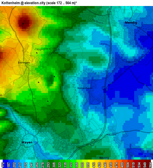
Below is the Elevation map of Kottenheim, which displays elevation range with different colors. Scale of the first map is from 172 to 564 m (564 to 1850 ft) with average elevation of 281.3 meters (=923 ft) [note 1]
These maps also provides idea of topography and contour of this city, they are displayed at different zoom levels. More info about maps, scale and edge coordinates you can find below images.
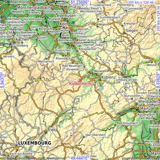
| \ | Map #1 | Topo.Map |
| Scale [m] | 172..564 m | × |
| Scale [ft] | 564..1850 ft | × |
| Average | 281.3 m = 923 ft | × |
| Width | 6.24 km = 3.9 mi | 199.5 km = 124 mi |
| Height | 6.24 km = 3.9 mi | 199.5 km = 124 mi |
| ↑Max Latitude | 50.378033° | 51.23886° |
| Latitude at center | 50.35° | 50.35° |
| ↓Min Latitude | 50.32195° | 49.44418° |
| ← Min Longitude | 7.206055° | 5.84375° |
| Longitude center | 7.25° | 7.25° |
| →Max Longitude | 7.293945° | 8.65625° |
Nearby cities:
Cities around Kottenheim sort by population:
• Mayen elevation 238 m
3.1 km,  218°
218°
• Mendig 195 m
3 km,  51°
51°
• Polch 214 m
7.2 km,  141°
141°
• Kruft 156 m
7 km,  57°
57°
• Nickenich 218 m
9 km,  37°
37°
• Ettringen 388 m
2.4 km,  270°
270°
• Bell 382 m
3.9 km,  342°
342°
• Thür 191 m
2.1 km,  68°
68°
• Rieden 450 m
7.3 km,  319°
319°
• Wehr 354 m
7.8 km, 342°
• Kehrig 362 m
7.8 km,  197°
197°
• Kirchwald 508 m
7.3 km,  284°
284°
Multilingual:
 En español:
Kottenheim elevación 231 m.
 En France:
Kottenheim élévation 231 m.
 Auf Deutsch:
Kottenheim höhe über dem Meeresspiegel ist 231 m.

Sources and notes:
- [note 1] Map square and city borders are not equal. Map elevation data is calculated only from area inside that square.
- [src 1] Elevation data from geonames database provided with same terms of usage.
- [src 2] The elevation map of Kottenheim is generated using elevation data from NASA's 3 arcsec (90m) resolution SRTM data.
- [src 3] Base (background) map © OpenStreetMap contributors tiles are generated by Geofabrik and OpenTopoMap.
Copyright & License:
This Kottenheim Elevation Map is licensed under CC BY-SA. You may reuse any part from this page, if you give a proper credit by linking to this URL:
 More info on terms of use page.