Krauchenwies elevation
Krauchenwies (Baden-Württemberg, Tübingen Region), Germany elevation is 585 meters and Krauchenwies elevation in feet is 1919 ft above sea level [src 1]. Krauchenwies is a seat of a fourth-order administrative division (feature code) with elevation that is 327 meters (1073 ft) bigger than average city elevation in Germany.
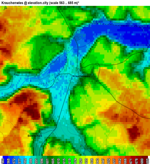
Below is the Elevation map of Krauchenwies, which displays elevation range with different colors. Scale of the first map is from 563 to 685 m (1847 to 2247 ft) with average elevation of 620 meters (=2034 ft) [note 1]
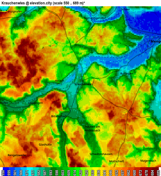
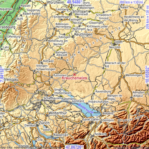
These maps also provides idea of topography and contour of this city, they are displayed at different zoom levels. More info about maps, scale and edge coordinates you can find below images.
| \ | Map #1 | Map #2 | Topo.Map |
| Scale [m] | 563..685 m | 550..689 m | × |
| Scale [ft] | 1847..2247 ft | 1804..2260 ft | × |
| Average | 620 m = 2034 ft | 623.6 m = 2046 ft | × |
| Width | 6.54 km = 4.1 mi | 13.07 km = 8.1 mi | 209.2 km = 130 mi |
| Height | 6.54 km = 4.1 mi | 13.07 km = 8.1 mi | 209.2 km = 130 mi |
| ↑Max Latitude | 48.045897° | 48.075268° | 48.9486° |
| Latitude at center | 48.01651° | 48.01651° | 48.01651° |
| ↓Min Latitude | 47.987106° | 47.957685° | 47.06726° |
| ← Min Longitude | 9.203625° | 9.159679° | 7.84132° |
| Longitude center | 9.24757° | 9.24757° | 9.24757° |
| →Max Longitude | 9.291515° | 9.335461° | 10.65382° |
Nearby cities:
Cities around Krauchenwies sort by population:
• Sigmaringen elevation 592 m
8.1 km,  350°
350°
• Pfullendorf 669 m
10.1 km,  175°
175°
• Mengen 562 m
7.1 km,  59°
59°
• Meßkirch 603 m
10.2 km,  256°
256°
• Ostrach 610 m
12.5 km,  126°
126°
• Hohentengen 575 m
9.8 km,  81°
81°
• Sigmaringendorf 568 m
5.6 km,  11°
11°
• Bingen 610 m
10.7 km, 9°
• Inzigkofen 625 m
7.8 km,  319°
319°
• Wald 657 m
11 km,  213°
213°
• Scheer 561 m
7.2 km,  29°
29°
• Ennetach 560 m
6.7 km,  53°
53°
Multilingual:
 En español:
Krauchenwies elevación 585 m.
 En France:
Krauchenwies élévation 585 m.
 Auf Deutsch:
Krauchenwies höhe über dem Meeresspiegel ist 585 m.

Sources and notes:
- [note 1] Map square and city borders are not equal. Map elevation data is calculated only from area inside that square.
- [src 1] Elevation data from geonames database provided with same terms of usage.
- [src 2] The elevation map of Krauchenwies is generated using elevation data from NASA's 3 arcsec (90m) resolution SRTM data.
- [src 3] Base (background) map © OpenStreetMap contributors tiles are generated by Geofabrik and OpenTopoMap.
Copyright & License:
This Krauchenwies Elevation Map is licensed under CC BY-SA. You may reuse any part from this page, if you give a proper credit by linking to this URL:
 More info on terms of use page.