Kreuztal elevation
Kreuztal (North Rhine-Westphalia, Regierungsbezirk Arnsberg), Germany elevation is 336 meters and Kreuztal elevation in feet is 1102 ft above sea level [src 1]. Kreuztal is a populated place (feature code) with elevation that is 78 meters (256 ft) bigger than average city elevation in Germany.
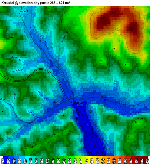
Below is the Elevation map of Kreuztal, which displays elevation range with different colors. Scale of the first map is from 266 to 621 m (873 to 2037 ft) with average elevation of 367.7 meters (=1206 ft) [note 1]
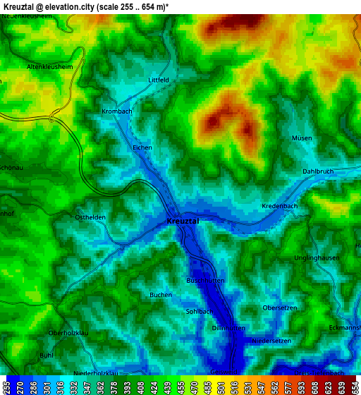
These maps also provides idea of topography and contour of this city, they are displayed at different zoom levels. More info about maps, scale and edge coordinates you can find below images.
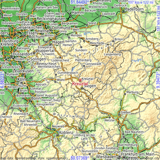
| \ | Map #1 | Map #2 | Topo.Map |
| Scale [m] | 266..621 m | 255..654 m | × |
| Scale [ft] | 873..2037 ft | 837..2146 ft | × |
| Average | 367.7 m = 1206 ft | 391.5 m = 1284 ft | × |
| Width | 6.15 km = 3.8 mi | 12.31 km = 7.6 mi | 196.9 km = 122.3 mi |
| Height | 6.15 km = 3.8 mi | 12.31 km = 7.6 mi | 196.9 km = 122.3 mi |
| ↑Max Latitude | 50.995417° | 51.023067° | 51.84492° |
| Latitude at center | 50.96775° | 50.96775° | 50.96775° |
| ↓Min Latitude | 50.940067° | 50.912367° | 50.07369° |
| ← Min Longitude | 7.944535° | 7.900589° | 6.58223° |
| Longitude center | 7.98848° | 7.98848° | 7.98848° |
| →Max Longitude | 8.032425° | 8.076371° | 9.39473° |
Nearby cities:
Cities around Kreuztal sort by population:
• Siegen elevation 272 m
10.6 km,  166°
166°
• Olpe 321 m
11.8 km,  305°
305°
• Netphen 300 m
9.7 km,  126°
126°
• Wenden 405 m
8.5 km,  269°
269°
• Freudenberg 297 m
11.2 km,  225°
225°
• Hilchenbach 357 m
9.1 km,  69°
69°
• Kirchhundem 308 m
14.9 km,  28°
28°
• Drolshagen 357 m
16.3 km,  292°
292°
• Mudersbach 248 m
16.2 km,  191°
191°
• Niederfischbach 296 m
15.6 km,  213°
213°
• Brachbach 224 m
17.2 km, 192°
• Friesenhagen 297 m
14.4 km,  240°
240°
Multilingual:
 En español:
Kreuztal elevación 336 m.
 En France:
Kreuztal élévation 336 m.
 Auf Deutsch:
Kreuztal höhe über dem Meeresspiegel ist 336 m.

Sources and notes:
- [note 1] Map square and city borders are not equal. Map elevation data is calculated only from area inside that square.
- [src 1] Elevation data from geonames database provided with same terms of usage.
- [src 2] The elevation map of Kreuztal is generated using elevation data from NASA's 3 arcsec (90m) resolution SRTM data.
- [src 3] Base (background) map © OpenStreetMap contributors tiles are generated by Geofabrik and OpenTopoMap.
Copyright & License:
This Kreuztal Elevation Map is licensed under CC BY-SA. You may reuse any part from this page, if you give a proper credit by linking to this URL:
 More info on terms of use page.