Lachen elevation
Lachen (Bavaria, Swabia), Germany elevation is 651 meters and Lachen elevation in feet is 2136 ft above sea level [src 1]. Lachen is a seat of a fourth-order administrative division (feature code) with elevation that is 393 meters (1289 ft) bigger than average city elevation in Germany.
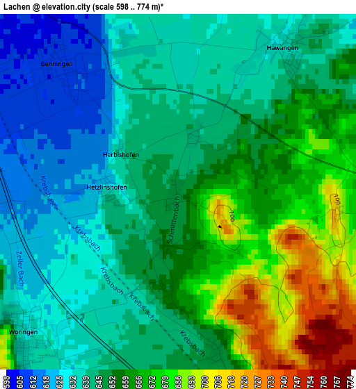
Below is the Elevation map of Lachen, which displays elevation range with different colors. Scale of the first map is from 598 to 774 m (1962 to 2539 ft) with average elevation of 651.4 meters (=2137 ft) [note 1]
These maps also provides idea of topography and contour of this city, they are displayed at different zoom levels. More info about maps, scale and edge coordinates you can find below images.
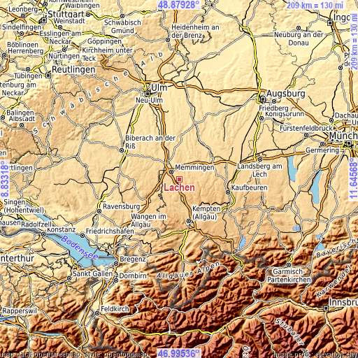
| \ | Map #1 | Topo.Map |
| Scale [m] | 598..774 m | × |
| Scale [ft] | 1962..2539 ft | × |
| Average | 651.4 m = 2137 ft | × |
| Width | 6.55 km = 4.1 mi | 209.5 km = 130.2 mi |
| Height | 6.55 km = 4.1 mi | 209.5 km = 130.2 mi |
| ↑Max Latitude | 47.975328° | 48.87928° |
| Latitude at center | 47.9459° | 47.9459° |
| ↓Min Latitude | 47.916456° | 46.99536° |
| ← Min Longitude | 10.195485° | 8.83318° |
| Longitude center | 10.23943° | 10.23943° |
| →Max Longitude | 10.283375° | 11.64568° |
Nearby cities:
Cities around Lachen sort by population:
• Memmingen elevation 598 m
5.8 km,  316°
316°
• Ottobeuren 655 m
4.5 km,  96°
96°
• Amendingen 593 m
7.8 km, 324°
• Memmingerberg 633 m
4.8 km,  345°
345°
• Benningen 607 m
2.9 km, 323°
• Wolfertschwenden 679 m
6.2 km,  160°
160°
• Woringen 638 m
4.4 km,  222°
222°
• Trunkelsberg 626 m
6.2 km,  344°
344°
• Kronburg 702 m
7.7 km,  232°
232°
• Hawangen 641 m
3.1 km,  41°
41°
• Ungerhausen 619 m
6.9 km,  16°
16°
• Wald 690 m
5.4 km,  57°
57°
Multilingual:
 En español:
Lachen elevación 651 m.
 En France:
Lachen élévation 651 m.


Sources and notes:
- [note 1] Map square and city borders are not equal. Map elevation data is calculated only from area inside that square.
- [src 1] Elevation data from geonames database provided with same terms of usage.
- [src 2] The elevation map of Lachen is generated using elevation data from NASA's 3 arcsec (90m) resolution SRTM data.
- [src 3] Base (background) map © OpenStreetMap contributors tiles are generated by Geofabrik and OpenTopoMap.
Copyright & License:
This Lachen Elevation Map is licensed under CC BY-SA. You may reuse any part from this page, if you give a proper credit by linking to this URL:
 More info on terms of use page.