Ottobeuren elevation
Ottobeuren (Bavaria, Swabia), Germany elevation is 655 meters and Ottobeuren elevation in feet is 2149 ft above sea level [src 1]. Ottobeuren is a populated place (feature code) with elevation that is 397 meters (1302 ft) bigger than average city elevation in Germany.
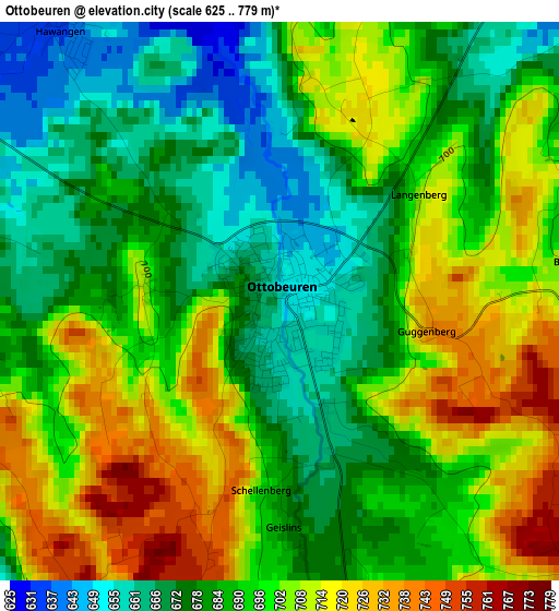
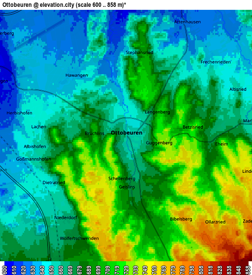
Below is the Elevation map of Ottobeuren, which displays elevation range with different colors. Scale of the first map is from 625 to 779 m (2051 to 2556 ft) with average elevation of 692.2 meters (=2271 ft) [note 1]
These maps also provides idea of topography and contour of this city, they are displayed at different zoom levels. More info about maps, scale and edge coordinates you can find below images.
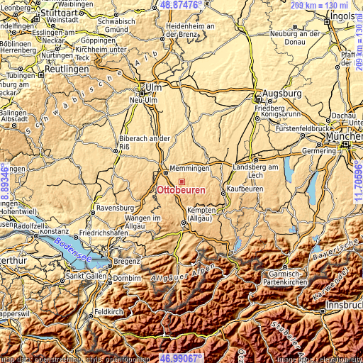
| \ | Map #1 | Map #2 | Topo.Map |
| Scale [m] | 625..779 m | 600..858 m | × |
| Scale [ft] | 2051..2556 ft | 1969..2815 ft | × |
| Average | 692.2 m = 2271 ft | 680.2 m = 2232 ft | × |
| Width | 6.55 km = 4.1 mi | 13.09 km = 8.1 mi | 209.5 km = 130.2 mi |
| Height | 6.55 km = 4.1 mi | 13.09 km = 8.1 mi | 209.5 km = 130.2 mi |
| ↑Max Latitude | 47.97073° | 48.000144° | 48.87476° |
| Latitude at center | 47.9413° | 47.9413° | 47.9413° |
| ↓Min Latitude | 47.911853° | 47.882389° | 46.99067° |
| ← Min Longitude | 10.255765° | 10.211819° | 8.89346° |
| Longitude center | 10.29971° | 10.29971° | 10.29971° |
| →Max Longitude | 10.343655° | 10.387601° | 11.70596° |
Nearby cities:
Cities around Ottobeuren sort by population:
• Markt Rettenbach elevation 676 m
7.2 km,  84°
84°
• Memmingerberg 633 m
7.7 km,  312°
312°
• Sontheim 620 m
8.4 km,  29°
29°
• Benningen 607 m
6.8 km,  294°
294°
• Westerheim 599 m
8.4 km,  0°
0°
• Wolfertschwenden 679 m
5.8 km,  204°
204°
• Woringen 638 m
7.9 km,  249°
249°
• Trunkelsberg 626 m
9 km,  316°
316°
• Lachen 651 m
4.5 km,  276°
276°
• Hawangen 641 m
3.7 km, 318°
• Ungerhausen 619 m
7.6 km,  341°
341°
• Wald 690 m
3.4 km, 1°
Multilingual:
 En español:
Ottobeuren elevación 655 m.
 En France:
Ottobeuren élévation 655 m.
 Auf Deutsch:
Ottobeuren höhe über dem Meeresspiegel ist 655 m.

Sources and notes:
- [note 1] Map square and city borders are not equal. Map elevation data is calculated only from area inside that square.
- [src 1] Elevation data from geonames database provided with same terms of usage.
- [src 2] The elevation map of Ottobeuren is generated using elevation data from NASA's 3 arcsec (90m) resolution SRTM data.
- [src 3] Base (background) map © OpenStreetMap contributors tiles are generated by Geofabrik and OpenTopoMap.
Copyright & License:
This Ottobeuren Elevation Map is licensed under CC BY-SA. You may reuse any part from this page, if you give a proper credit by linking to this URL:
 More info on terms of use page.