Landau an der Isar elevation
Landau an der Isar (Bavaria, Lower Bavaria), Germany elevation is 344 meters and Landau an der Isar elevation in feet is 1129 ft above sea level [src 1]. Landau an der Isar is a populated place (feature code) with elevation that is 86 meters (282 ft) bigger than average city elevation in Germany.
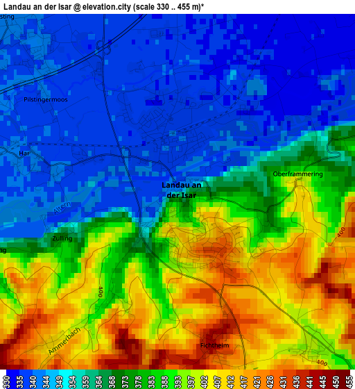
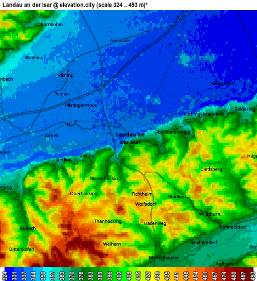
Below is the Elevation map of Landau an der Isar, which displays elevation range with different colors. Scale of the first map is from 330 to 455 m (1083 to 1493 ft) with average elevation of 371.4 meters (=1219 ft) [note 1]
These maps also provides idea of topography and contour of this city, they are displayed at different zoom levels. More info about maps, scale and edge coordinates you can find below images.
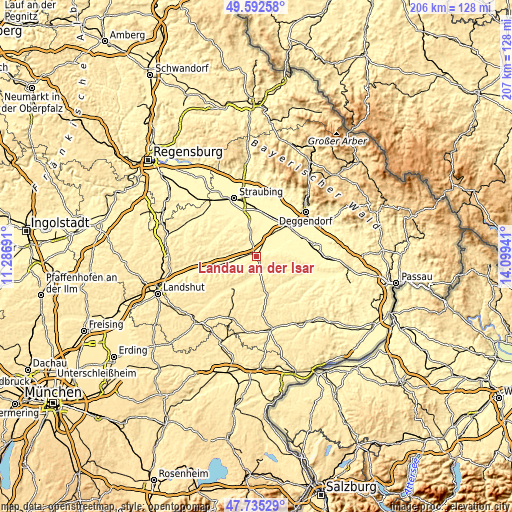
| \ | Map #1 | Map #2 | Topo.Map |
| Scale [m] | 330..455 m | 324..493 m | × |
| Scale [ft] | 1083..1493 ft | 1063..1617 ft | × |
| Average | 371.4 m = 1219 ft | 375.7 m = 1233 ft | × |
| Width | 6.45 km = 4 mi | 12.91 km = 8 mi | 206.5 km = 128.3 mi |
| Height | 6.45 km = 4 mi | 12.91 km = 8 mi | 206.5 km = 128.3 mi |
| ↑Max Latitude | 48.701501° | 48.730496° | 49.59258° |
| Latitude at center | 48.67249° | 48.67249° | 48.67249° |
| ↓Min Latitude | 48.643462° | 48.614417° | 47.73529° |
| ← Min Longitude | 12.649215° | 12.605269° | 11.28691° |
| Longitude center | 12.69316° | 12.69316° | 12.69316° |
| →Max Longitude | 12.737105° | 12.781051° | 14.09941° |
Nearby cities:
Cities around Landau an der Isar sort by population:
• Reisbach elevation 406 m
12.4 km,  202°
202°
• Wallersdorf 335 m
8.3 km,  28°
28°
• Eichendorf 358 m
12.7 km,  110°
110°
• Pilsting 343 m
4.4 km,  315°
315°
• Moosthenning 369 m
14.4 km,  271°
271°
• Simbach 445 m
12.3 km,  164°
164°
• Mamming 364 m
6.7 km,  249°
249°
• Oberschneiding 359 m
14.2 km,  344°
344°
• Gottfrieding 360 m
12.2 km, 251°
• Otzing 326 m
13 km,  40°
40°
• Wallerfing 359 m
13.8 km,  84°
84°
• Oberpöring 343 m
10.2 km,  71°
71°
Multilingual:
 En español:
Landau an der Isar elevación 344 m.
 En France:
Landau an der Isar élévation 344 m.
 Auf Deutsch:
Landau an der Isar höhe über dem Meeresspiegel ist 344 m.
 На русском:
Ландау-ан-дер-Изар высота над уровнем моря 344 м
Sources and notes:
- [note 1] Map square and city borders are not equal. Map elevation data is calculated only from area inside that square.
- [src 1] Elevation data from geonames database provided with same terms of usage.
- [src 2] The elevation map of Landau an der Isar is generated using elevation data from NASA's 3 arcsec (90m) resolution SRTM data.
- [src 3] Base (background) map © OpenStreetMap contributors tiles are generated by Geofabrik and OpenTopoMap.
Copyright & License:
This Landau an der Isar Elevation Map is licensed under CC BY-SA. You may reuse any part from this page, if you give a proper credit by linking to this URL:
 More info on terms of use page.