Mamming elevation
Mamming (Bavaria, Lower Bavaria), Germany elevation is 364 meters and Mamming elevation in feet is 1194 ft above sea level [src 1]. Mamming is a seat of a fourth-order administrative division (feature code) with elevation that is 106 meters (348 ft) bigger than average city elevation in Germany.
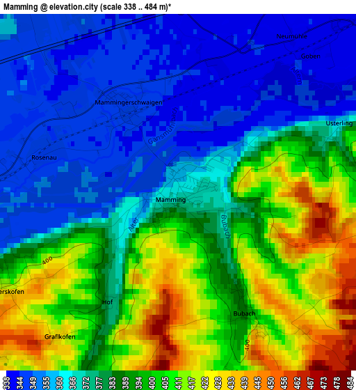
Below is the Elevation map of Mamming, which displays elevation range with different colors. Scale of the first map is from 338 to 484 m (1109 to 1588 ft) with average elevation of 382.5 meters (=1255 ft) [note 1]
These maps also provides idea of topography and contour of this city, they are displayed at different zoom levels. More info about maps, scale and edge coordinates you can find below images.
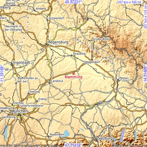
| \ | Map #1 | Topo.Map |
| Scale [m] | 338..484 m | × |
| Scale [ft] | 1109..1588 ft | × |
| Average | 382.5 m = 1255 ft | × |
| Width | 6.46 km = 4 mi | 206.6 km = 128.4 mi |
| Height | 6.46 km = 4 mi | 206.6 km = 128.4 mi |
| ↑Max Latitude | 48.680763° | 49.57221° |
| Latitude at center | 48.65174° | 48.65174° |
| ↓Min Latitude | 48.6227° | 47.71415° |
| ← Min Longitude | 12.563895° | 11.20159° |
| Longitude center | 12.60784° | 12.60784° |
| →Max Longitude | 12.651785° | 14.01409° |
Nearby cities:
Cities around Mamming sort by population:
• Dingolfing elevation 357 m
8.5 km,  263°
263°
• Landau an der Isar 344 m
6.7 km,  69°
69°
• Reisbach 406 m
9.2 km,  170°
170°
• Ruhstorf 444 m
13.6 km,  156°
156°
• Wallersdorf 335 m
14 km,  46°
46°
• Pilsting 343 m
6.3 km,  29°
29°
• Moosthenning 369 m
8.6 km,  288°
288°
• Frontenhausen 414 m
13 km,  205°
205°
• Marklkofen 418 m
11.7 km,  194°
194°
• Simbach 445 m
13.5 km,  134°
134°
• Loiching 439 m
13.4 km,  253°
253°
• Gottfrieding 360 m
5.5 km, 253°
Multilingual:
 En español:
Mamming elevación 364 m.
 En France:
Mamming élévation 364 m.


Sources and notes:
- [note 1] Map square and city borders are not equal. Map elevation data is calculated only from area inside that square.
- [src 1] Elevation data from geonames database provided with same terms of usage.
- [src 2] The elevation map of Mamming is generated using elevation data from NASA's 3 arcsec (90m) resolution SRTM data.
- [src 3] Base (background) map © OpenStreetMap contributors tiles are generated by Geofabrik and OpenTopoMap.
Copyright & License:
This Mamming Elevation Map is licensed under CC BY-SA. You may reuse any part from this page, if you give a proper credit by linking to this URL:
 More info on terms of use page.