Langenstein elevation
Langenstein (Saxony-Anhalt), Germany elevation is 149 meters and Langenstein elevation in feet is 489 ft above sea level [src 1]. Langenstein is a populated place (feature code) with elevation that is 109 meters (358 ft) smaller than average city elevation in Germany.
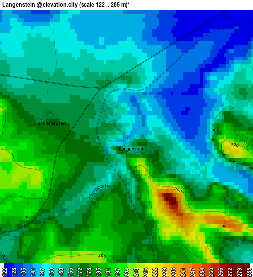
Below is the Elevation map of Langenstein, which displays elevation range with different colors. Scale of the first map is from 122 to 285 m (400 to 935 ft) with average elevation of 167.1 meters (=548 ft) [note 1]
These maps also provides idea of topography and contour of this city, they are displayed at different zoom levels. More info about maps, scale and edge coordinates you can find below images.
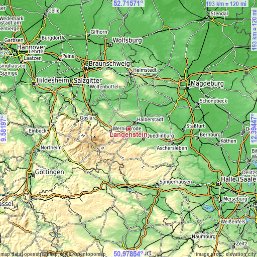
| \ | Map #1 | Topo.Map |
| Scale [m] | 122..285 m | × |
| Scale [ft] | 400..935 ft | × |
| Average | 167.1 m = 548 ft | × |
| Width | 6.04 km = 3.8 mi | 193.2 km = 120 mi |
| Height | 6.04 km = 3.8 mi | 193.1 km = 120 mi |
| ↑Max Latitude | 51.882644° | 52.71571° |
| Latitude at center | 51.85551° | 51.85551° |
| ↓Min Latitude | 51.828359° | 50.97854° |
| ← Min Longitude | 10.944275° | 9.58197° |
| Longitude center | 10.98822° | 10.98822° |
| →Max Longitude | 11.032165° | 12.39447° |
Nearby cities:
Cities around Langenstein sort by population:
• Halberstadt elevation 123 m
6.5 km,  46°
46°
• Blankenburg 229 m
7.6 km,  197°
197°
• Thale 174 m
12.4 km,  163°
163°
• Derenburg 157 m
5.6 km,  287°
287°
• Harsleben 117 m
7.8 km,  80°
80°
• Westerhausen 145 m
7.3 km,  139°
139°
• Heudeber 181 m
11.2 km,  297°
297°
• Hüttenrode 479 m
11.3 km,  211°
211°
• Ströbeck 149 m
7.2 km,  335°
335°
• Timmenrode 199 m
9.5 km,  172°
172°
• Weddersleben 146 m
12 km,  146°
146°
• Groß Quenstedt 101 m
12.4 km, 45°
Multilingual:
 En español:
Langenstein elevación 149 m.
 En France:
Langenstein élévation 149 m.
 Auf Deutsch:
Langenstein höhe über dem Meeresspiegel ist 149 m.

Sources and notes:
- [note 1] Map square and city borders are not equal. Map elevation data is calculated only from area inside that square.
- [src 1] Elevation data from geonames database provided with same terms of usage.
- [src 2] The elevation map of Langenstein is generated using elevation data from NASA's 3 arcsec (90m) resolution SRTM data.
- [src 3] Base (background) map © OpenStreetMap contributors tiles are generated by Geofabrik and OpenTopoMap.
Copyright & License:
This Langenstein Elevation Map is licensed under CC BY-SA. You may reuse any part from this page, if you give a proper credit by linking to this URL:
 More info on terms of use page.