Leitzkau elevation
Leitzkau (Saxony-Anhalt), Germany elevation is 107 meters and Leitzkau elevation in feet is 351 ft above sea level [src 1]. Leitzkau is a populated place (feature code) with elevation that is 151 meters (495 ft) smaller than average city elevation in Germany.
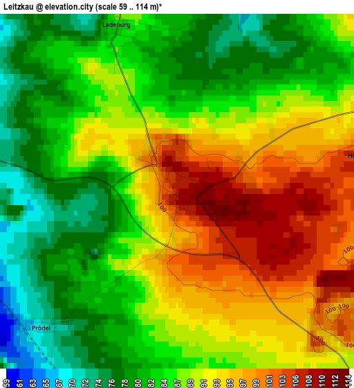
Below is the Elevation map of Leitzkau, which displays elevation range with different colors. Scale of the first map is from 59 to 114 m (194 to 374 ft) with average elevation of 87.9 meters (=288 ft) [note 1]
These maps also provides idea of topography and contour of this city, they are displayed at different zoom levels. More info about maps, scale and edge coordinates you can find below images.
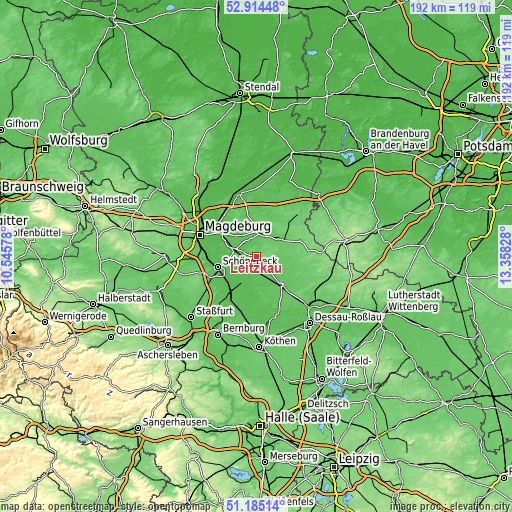
| \ | Map #1 | Topo.Map |
| Scale [m] | 59..114 m | × |
| Scale [ft] | 194..374 ft | × |
| Average | 87.9 m = 288 ft | × |
| Width | 6.01 km = 3.7 mi | 192.3 km = 119.5 mi |
| Height | 6.01 km = 3.7 mi | 192.3 km = 119.5 mi |
| ↑Max Latitude | 52.085192° | 52.91448° |
| Latitude at center | 52.05818° | 52.05818° |
| ↓Min Latitude | 52.031152° | 51.18514° |
| ← Min Longitude | 11.908085° | 10.54578° |
| Longitude center | 11.95203° | 11.95203° |
| →Max Longitude | 11.995975° | 13.35828° |
Nearby cities:
Cities around Leitzkau sort by population:
• Schönebeck elevation 53 m
15.8 km,  253°
253°
• Zerbst 67 m
13.7 km,  138°
138°
• Möckern 63 m
9.2 km,  0°
0°
• Gommern 56 m
9 km,  281°
281°
• Barby 52 m
11.2 km,  205°
205°
• Biederitz 43 m
19 km,  302°
302°
• Loburg 77 m
10.7 km,  53°
53°
• Groß Rosenburg 53 m
16.2 km,  194°
194°
• Eggersdorf 55 m
18.9 km,  241°
241°
• Lindau 80 m
10.9 km,  102°
102°
• Plötzky 53 m
10.3 km,  266°
266°
• Wahlitz 48 m
12.8 km,  293°
293°
Multilingual:
 En español:
Leitzkau elevación 107 m.
 En France:
Leitzkau élévation 107 m.
 Auf Deutsch:
Leitzkau höhe über dem Meeresspiegel ist 107 m.

Sources and notes:
- [note 1] Map square and city borders are not equal. Map elevation data is calculated only from area inside that square.
- [src 1] Elevation data from geonames database provided with same terms of usage.
- [src 2] The elevation map of Leitzkau is generated using elevation data from NASA's 3 arcsec (90m) resolution SRTM data.
- [src 3] Base (background) map © OpenStreetMap contributors tiles are generated by Geofabrik and OpenTopoMap.
Copyright & License:
This Leitzkau Elevation Map is licensed under CC BY-SA. You may reuse any part from this page, if you give a proper credit by linking to this URL:
 More info on terms of use page.