Liebenau elevation
Liebenau (Lower Saxony), Germany elevation is 30 meters and Liebenau elevation in feet is 98 ft above sea level [src 1]. Liebenau is a populated place (feature code) with elevation that is 228 meters (748 ft) smaller than average city elevation in Germany.
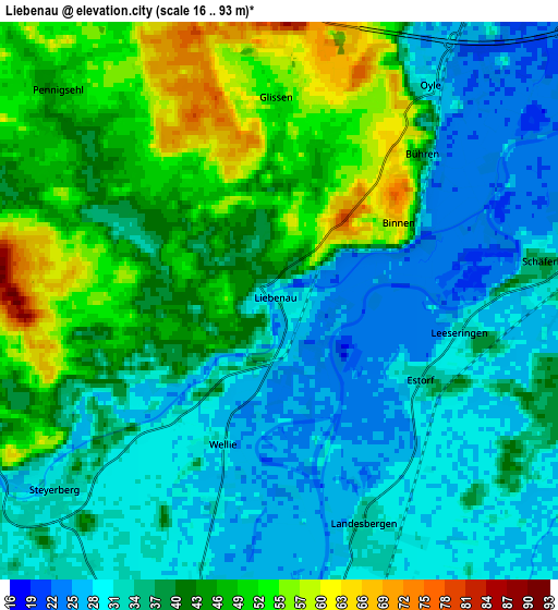
Below is the Elevation map of Liebenau, which displays elevation range with different colors. Scale of the first map is from 16 to 81 m (52 to 266 ft) with average elevation of 37.1 meters (=122 ft) [note 1]
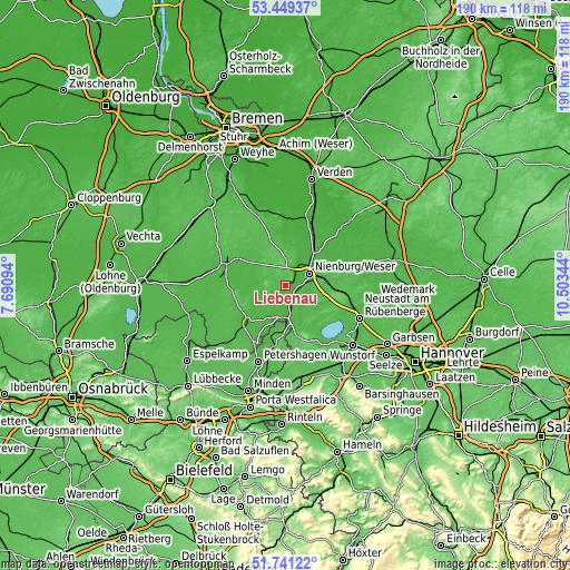
These maps also provides idea of topography and contour of this city, they are displayed at different zoom levels. More info about maps, scale and edge coordinates you can find below images.

| \ | Map #1 | Map #2 | Topo.Map |
| Scale [m] | 16..81 m | 16..93 m | × |
| Scale [ft] | 52..266 ft | 52..305 ft | × |
| Average | 37.1 m = 122 ft | 38.5 m = 126 ft | × |
| Width | 5.94 km = 3.7 mi | 11.87 km = 7.4 mi | 189.9 km = 118 mi |
| Height | 5.94 km = 3.7 mi | 11.87 km = 7.4 mi | 189.9 km = 118 mi |
| ↑Max Latitude | 52.630301° | 52.656966° | 53.44937° |
| Latitude at center | 52.60362° | 52.60362° | 52.60362° |
| ↓Min Latitude | 52.576923° | 52.550209° | 51.74122° |
| ← Min Longitude | 9.053245° | 9.009299° | 7.69094° |
| Longitude center | 9.09719° | 9.09719° | 9.09719° |
| →Max Longitude | 9.141135° | 9.185081° | 10.50344° |
Nearby cities:
Cities around Liebenau sort by population:
• Nienburg elevation 28 m
9.6 km,  60°
60°
• Stolzenau 30 m
9.9 km,  192°
192°
• Steyerberg 29 m
6.2 km,  232°
232°
• Marklohe 48 m
7.8 km,  22°
22°
• Landesbergen 30 m
5.6 km,  160°
160°
• Husum 42 m
11.1 km,  111°
111°
• Leese 35 m
11.6 km,  173°
173°
• Drakenburg 26 m
12 km,  39°
39°
• Estorf 32 m
3.4 km,  119°
119°
• Borstel 45 m
11.4 km,  310°
310°
• Pennigsehl 47 m
6.4 km, 311°
• Binnen 60 m
2.8 km, 59°
Multilingual:
 En español:
Liebenau elevación 30 m.
 En France:
Liebenau élévation 30 m.


Sources and notes:
- [note 1] Map square and city borders are not equal. Map elevation data is calculated only from area inside that square.
- [src 1] Elevation data from geonames database provided with same terms of usage.
- [src 2] The elevation map of Liebenau is generated using elevation data from NASA's 3 arcsec (90m) resolution SRTM data.
- [src 3] Base (background) map © OpenStreetMap contributors tiles are generated by Geofabrik and OpenTopoMap.
Copyright & License:
This Liebenau Elevation Map is licensed under CC BY-SA. You may reuse any part from this page, if you give a proper credit by linking to this URL:
 More info on terms of use page.