Lorch elevation
Lorch (Baden-Württemberg, Regierungsbezirk Stuttgart), Germany elevation is 288 meters and Lorch elevation in feet is 945 ft above sea level [src 1]. Lorch is a populated place (feature code) with elevation that is 30 meters (98 ft) bigger than average city elevation in Germany.
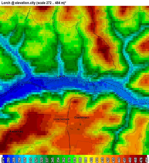
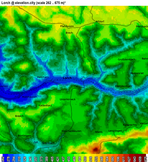
Below is the Elevation map of Lorch, which displays elevation range with different colors. Scale of the first map is from 272 to 484 m (892 to 1588 ft) with average elevation of 380.2 meters (=1247 ft) [note 1]
These maps also provides idea of topography and contour of this city, they are displayed at different zoom levels. More info about maps, scale and edge coordinates you can find below images.
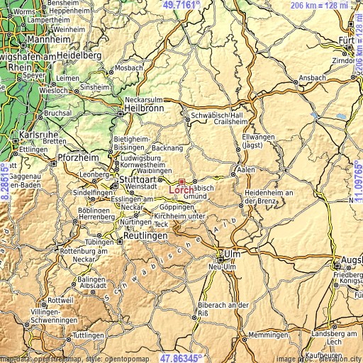
| \ | Map #1 | Map #2 | Topo.Map |
| Scale [m] | 272..484 m | 262..675 m | × |
| Scale [ft] | 892..1588 ft | 860..2215 ft | × |
| Average | 380.2 m = 1247 ft | 414.5 m = 1360 ft | × |
| Width | 6.44 km = 4 mi | 12.87 km = 8 mi | 206 km = 128 mi |
| Height | 6.44 km = 4 mi | 12.87 km = 8 mi | 206 km = 128 mi |
| ↑Max Latitude | 48.827269° | 48.856191° | 49.7161° |
| Latitude at center | 48.79833° | 48.79833° | 48.79833° |
| ↓Min Latitude | 48.769374° | 48.740402° | 47.86345° |
| ← Min Longitude | 9.647455° | 9.603509° | 8.28515° |
| Longitude center | 9.6914° | 9.6914° | 9.6914° |
| →Max Longitude | 9.735345° | 9.779291° | 11.09765° |
Nearby cities:
Cities around Lorch sort by population:
• Schwäbisch Gmünd elevation 325 m
7.8 km,  89°
89°
• Plüderhausen 270 m
7 km,  270°
270°
• Urbach 271 m
8.6 km,  283°
283°
• Alfdorf 488 m
5.4 km,  21°
21°
• Mutlangen 452 m
8.3 km,  68°
68°
• Rechberghausen 330 m
8.3 km,  204°
204°
• Wäschenbeuren 415 m
4.3 km,  183°
183°
• Wangen 382 m
9.6 km,  217°
217°
• Ottenbach 391 m
8 km,  148°
148°
• Adelberg 477 m
7.8 km,  239°
239°
• Birenbach 367 m
6.1 km, 201°
• Börtlingen 450 m
6.6 km, 221°
Multilingual:
 En español:
Lorch elevación 288 m.
 En France:
Lorch élévation 288 m.


Sources and notes:
- [note 1] Map square and city borders are not equal. Map elevation data is calculated only from area inside that square.
- [src 1] Elevation data from geonames database provided with same terms of usage.
- [src 2] The elevation map of Lorch is generated using elevation data from NASA's 3 arcsec (90m) resolution SRTM data.
- [src 3] Base (background) map © OpenStreetMap contributors tiles are generated by Geofabrik and OpenTopoMap.
Copyright & License:
This Lorch Elevation Map is licensed under CC BY-SA. You may reuse any part from this page, if you give a proper credit by linking to this URL:
 More info on terms of use page.