Maintal elevation
Maintal (Hesse, Regierungsbezirk Darmstadt), Germany elevation is 107 meters and Maintal elevation in feet is 351 ft above sea level [src 1]. Maintal is a populated place (feature code) with elevation that is 151 meters (495 ft) smaller than average city elevation in Germany.
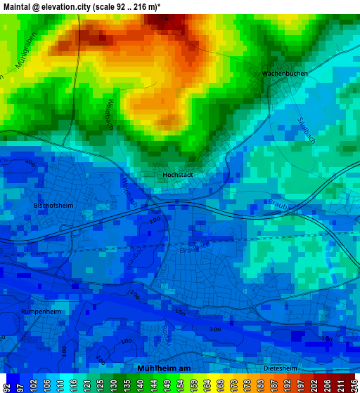
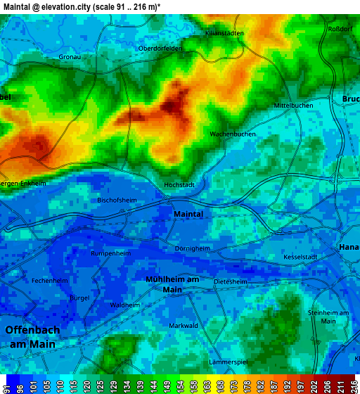
Below is the Elevation map of Maintal, which displays elevation range with different colors. Scale of the first map is from 92 to 216 m (302 to 709 ft) with average elevation of 121.4 meters (=398 ft) [note 1]
These maps also provides idea of topography and contour of this city, they are displayed at different zoom levels. More info about maps, scale and edge coordinates you can find below images.
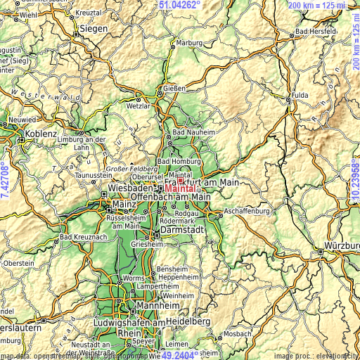
| \ | Map #1 | Map #2 | Topo.Map |
| Scale [m] | 92..216 m | 91..216 m | × |
| Scale [ft] | 302..709 ft | 299..709 ft | × |
| Average | 121.4 m = 398 ft | 123.2 m = 404 ft | × |
| Width | 6.26 km = 3.9 mi | 12.52 km = 7.8 mi | 200.4 km = 124.5 mi |
| Height | 6.26 km = 3.9 mi | 12.52 km = 7.8 mi | 200.4 km = 124.5 mi |
| ↑Max Latitude | 50.178151° | 50.206285° | 51.04262° |
| Latitude at center | 50.15° | 50.15° | 50.15° |
| ↓Min Latitude | 50.121832° | 50.093648° | 49.2404° |
| ← Min Longitude | 8.789385° | 8.745439° | 7.42708° |
| Longitude center | 8.83333° | 8.83333° | 8.83333° |
| →Max Longitude | 8.877275° | 8.921221° | 10.23958° |
Nearby cities:
Cities around Maintal sort by population:
• Frankfurt am Main elevation 113 m
11.3 km,  250°
250°
• Offenbach 113 m
7.3 km,  220°
220°
• Hanau am Main 107 m
6 km,  106°
106°
• Bad Vilbel 117 m
7.5 km,  295°
295°
• Mühlheim am Main 103 m
3.7 km,  180°
180°
• Obertshausen 123 m
8.8 km,  171°
171°
• Karben 118 m
9.9 km,  333°
333°
• Bruchköbel 116 m
7.1 km,  63°
63°
• Nidderau 125 m
10.1 km,  13°
13°
• Heusenstamm 130 m
10.8 km,  192°
192°
• Erlensee 114 m
10.4 km,  82°
82°
• Niederdorfelden 117 m
5.5 km, 334°
Multilingual:
 En español:
Maintal elevación 107 m.
 En France:
Maintal élévation 107 m.


Sources and notes:
- [note 1] Map square and city borders are not equal. Map elevation data is calculated only from area inside that square.
- [src 1] Elevation data from geonames database provided with same terms of usage.
- [src 2] The elevation map of Maintal is generated using elevation data from NASA's 3 arcsec (90m) resolution SRTM data.
- [src 3] Base (background) map © OpenStreetMap contributors tiles are generated by Geofabrik and OpenTopoMap.
Copyright & License:
This Maintal Elevation Map is licensed under CC BY-SA. You may reuse any part from this page, if you give a proper credit by linking to this URL:
 More info on terms of use page.