Mariental elevation
Mariental (Lower Saxony), Germany elevation is 129 meters and Mariental elevation in feet is 423 ft above sea level [src 1]. Mariental is a seat of a fourth-order administrative division (feature code) with elevation that is 129 meters (423 ft) smaller than average city elevation in Germany.
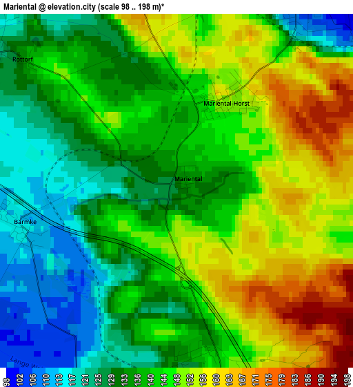
Below is the Elevation map of Mariental, which displays elevation range with different colors. Scale of the first map is from 98 to 198 m (322 to 650 ft) with average elevation of 141.1 meters (=463 ft) [note 1]
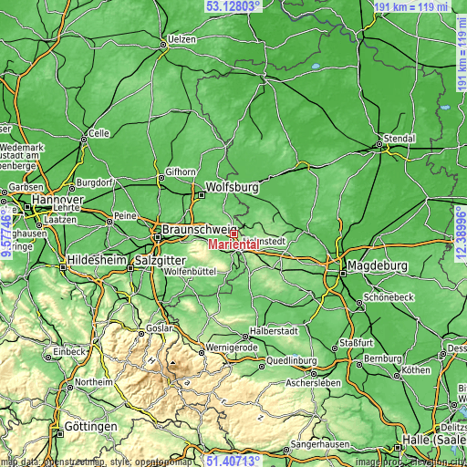
These maps also provides idea of topography and contour of this city, they are displayed at different zoom levels. More info about maps, scale and edge coordinates you can find below images.
| \ | Map #1 | Topo.Map |
| Scale [m] | 98..198 m | × |
| Scale [ft] | 322..650 ft | × |
| Average | 141.1 m = 463 ft | × |
| Width | 5.98 km = 3.7 mi | 191.3 km = 118.9 mi |
| Height | 5.98 km = 3.7 mi | 191.3 km = 118.9 mi |
| ↑Max Latitude | 52.30281° | 53.12803° |
| Latitude at center | 52.27593° | 52.27593° |
| ↓Min Latitude | 52.249033° | 51.40713° |
| ← Min Longitude | 10.939765° | 9.57746° |
| Longitude center | 10.98371° | 10.98371° |
| →Max Longitude | 11.027655° | 12.38996° |
Nearby cities:
Cities around Mariental sort by population:
• Helmstedt elevation 136 m
5.6 km,  161°
161°
• Königslutter am Elm 136 m
11.7 km,  256°
256°
• Velpke 81 m
15 km,  347°
347°
• Büddenstedt 137 m
12 km,  168°
168°
• Groß Twülpstedt 101 m
11.7 km,  338°
338°
• Grasleben 101 m
4 km,  31°
31°
• Weferlingen 87 m
6.4 km,  51°
51°
• Bahrdorf 76 m
12.3 km,  5°
5°
• Harbke 125 m
10.6 km, 156°
• Süpplingen 111 m
7.6 km,  225°
225°
• Sommersdorf 133 m
13.9 km,  150°
150°
• Wolsdorf 136 m
9.9 km,  197°
197°
Multilingual:
 En español:
Mariental elevación 129 m.
 En France:
Mariental élévation 129 m.
 Auf Deutsch:
Mariental höhe über dem Meeresspiegel ist 129 m.

Sources and notes:
- [note 1] Map square and city borders are not equal. Map elevation data is calculated only from area inside that square.
- [src 1] Elevation data from geonames database provided with same terms of usage.
- [src 2] The elevation map of Mariental is generated using elevation data from NASA's 3 arcsec (90m) resolution SRTM data.
- [src 3] Base (background) map © OpenStreetMap contributors tiles are generated by Geofabrik and OpenTopoMap.
Copyright & License:
This Mariental Elevation Map is licensed under CC BY-SA. You may reuse any part from this page, if you give a proper credit by linking to this URL:
 More info on terms of use page.