Mauern elevation
Mauern (Bavaria, Upper Bavaria), Germany elevation is 444 meters and Mauern elevation in feet is 1457 ft above sea level [src 1]. Mauern is a seat of a fourth-order administrative division (feature code) with elevation that is 186 meters (610 ft) bigger than average city elevation in Germany.
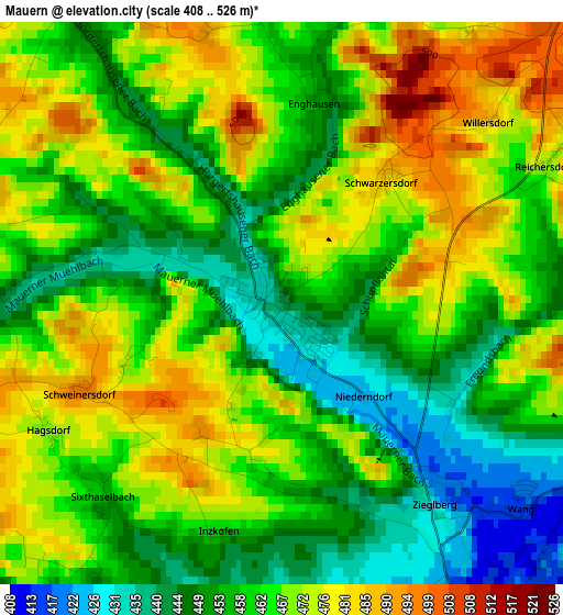
Below is the Elevation map of Mauern, which displays elevation range with different colors. Scale of the first map is from 408 to 526 m (1339 to 1726 ft) with average elevation of 462.5 meters (=1517 ft) [note 1]
These maps also provides idea of topography and contour of this city, they are displayed at different zoom levels. More info about maps, scale and edge coordinates you can find below images.
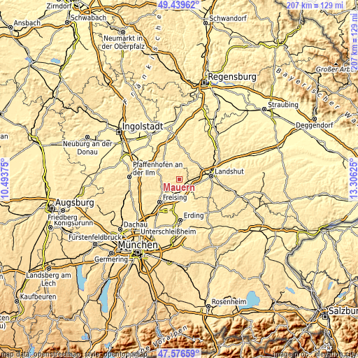
| \ | Map #1 | Topo.Map |
| Scale [m] | 408..526 m | × |
| Scale [ft] | 1339..1726 ft | × |
| Average | 462.5 m = 1517 ft | × |
| Width | 6.47 km = 4 mi | 207.1 km = 128.7 mi |
| Height | 6.47 km = 4 mi | 207.1 km = 128.7 mi |
| ↑Max Latitude | 48.545771° | 49.43962° |
| Latitude at center | 48.51667° | 48.51667° |
| ↓Min Latitude | 48.487552° | 47.57659° |
| ← Min Longitude | 11.856055° | 10.49375° |
| Longitude center | 11.9° | 11.9° |
| →Max Longitude | 11.943945° | 13.30625° |
Nearby cities:
Cities around Mauern sort by population:
• Moosburg elevation 415 m
5.8 km,  151°
151°
• Bruckberg 422 m
7 km,  84°
84°
• Nandlstadt 471 m
7.2 km,  287°
287°
• Langenbach 434 m
10 km,  201°
201°
• Haag an der Amper 437 m
8.4 km,  219°
219°
• Attenkirchen 519 m
10.4 km,  262°
262°
• Langenpreising 423 m
11.4 km, 152°
• Wang 417 m
3.6 km,  131°
131°
• Hörgertshausen 457 m
4.4 km,  326°
326°
• Obersüßbach 478 m
11.7 km,  18°
18°
• Volkenschwand 503 m
9.3 km,  352°
352°
• Gammelsdorf 493 m
5.2 km,  44°
44°
Multilingual:
 En español:
Mauern elevación 444 m.
 En France:
Mauern élévation 444 m.


Sources and notes:
- [note 1] Map square and city borders are not equal. Map elevation data is calculated only from area inside that square.
- [src 1] Elevation data from geonames database provided with same terms of usage.
- [src 2] The elevation map of Mauern is generated using elevation data from NASA's 3 arcsec (90m) resolution SRTM data.
- [src 3] Base (background) map © OpenStreetMap contributors tiles are generated by Geofabrik and OpenTopoMap.
Copyright & License:
This Mauern Elevation Map is licensed under CC BY-SA. You may reuse any part from this page, if you give a proper credit by linking to this URL:
 More info on terms of use page.