Melsbach elevation
Melsbach (Rheinland-Pfalz), Germany elevation is 181 meters and Melsbach elevation in feet is 594 ft above sea level [src 1]. Melsbach is a seat of a fourth-order administrative division (feature code) with elevation that is 77 meters (253 ft) smaller than average city elevation in Germany.
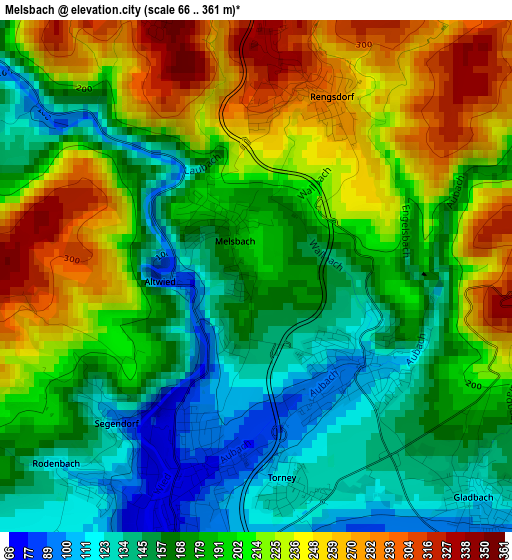
Below is the Elevation map of Melsbach, which displays elevation range with different colors. Scale of the first map is from 66 to 361 m (217 to 1184 ft) with average elevation of 192.7 meters (=632 ft) [note 1]
These maps also provides idea of topography and contour of this city, they are displayed at different zoom levels. More info about maps, scale and edge coordinates you can find below images.
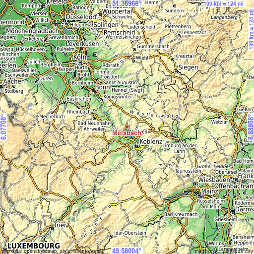
| \ | Map #1 | Topo.Map |
| Scale [m] | 66..361 m | × |
| Scale [ft] | 217..1184 ft | × |
| Average | 192.7 m = 632 ft | × |
| Width | 6.22 km = 3.9 mi | 199 km = 123.7 mi |
| Height | 6.22 km = 3.9 mi | 199 km = 123.7 mi |
| ↑Max Latitude | 50.511284° | 51.36968° |
| Latitude at center | 50.48333° | 50.48333° |
| ↓Min Latitude | 50.455359° | 49.58004° |
| ← Min Longitude | 7.439385° | 6.07708° |
| Longitude center | 7.48333° | 7.48333° |
| →Max Longitude | 7.527275° | 8.88958° |
Nearby cities:
Cities around Melsbach sort by population:
• Neuwied elevation 67 m
5.6 km,  189°
189°
• Andernach 81 m
8.1 km,  223°
223°
• Weißenthurm 79 m
7.7 km,  197°
197°
• Urmitz 60 m
7.8 km,  162°
162°
• Rengsdorf 269 m
2.2 km,  32°
32°
• Hausen 128 m
8.5 km,  320°
320°
• Leutesdorf 58 m
8 km,  242°
242°
• Niederbreitbach 130 m
6.9 km, 319°
• Anhausen 305 m
5.1 km,  68°
68°
• Heimbach 88 m
5.1 km,  136°
136°
• Ehlscheid 341 m
3.7 km,  341°
341°
• Bonefeld 345 m
4.5 km,  5°
5°
Multilingual:
 En español:
Melsbach elevación 181 m.
 En France:
Melsbach élévation 181 m.
 Auf Deutsch:
Melsbach höhe über dem Meeresspiegel ist 181 m.

Sources and notes:
- [note 1] Map square and city borders are not equal. Map elevation data is calculated only from area inside that square.
- [src 1] Elevation data from geonames database provided with same terms of usage.
- [src 2] The elevation map of Melsbach is generated using elevation data from NASA's 3 arcsec (90m) resolution SRTM data.
- [src 3] Base (background) map © OpenStreetMap contributors tiles are generated by Geofabrik and OpenTopoMap.
Copyright & License:
This Melsbach Elevation Map is licensed under CC BY-SA. You may reuse any part from this page, if you give a proper credit by linking to this URL:
 More info on terms of use page.