Weißenthurm elevation
Weißenthurm (Rheinland-Pfalz), Germany elevation is 79 meters and Weißenthurm elevation in feet is 259 ft above sea level [src 1]. Weißenthurm is a populated place (feature code) with elevation that is 179 meters (587 ft) smaller than average city elevation in Germany.
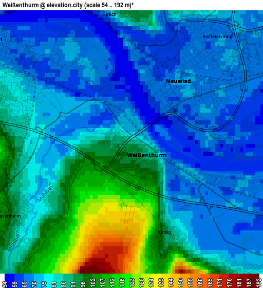
Below is the Elevation map of Weißenthurm, which displays elevation range with different colors. Scale of the first map is from 54 to 192 m (177 to 630 ft) with average elevation of 81.7 meters (=268 ft) [note 1]
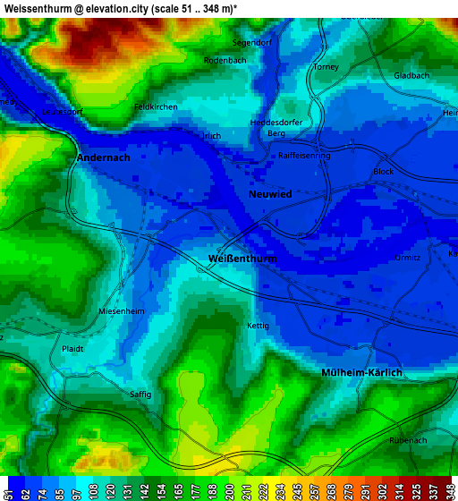
These maps also provides idea of topography and contour of this city, they are displayed at different zoom levels. More info about maps, scale and edge coordinates you can find below images.
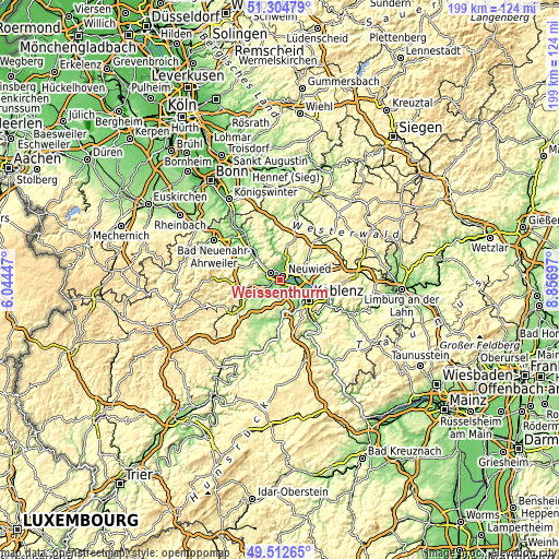
| \ | Map #1 | Map #2 | Topo.Map |
| Scale [m] | 54..192 m | 51..348 m | × |
| Scale [ft] | 177..630 ft | 167..1142 ft | × |
| Average | 81.7 m = 268 ft | 123.4 m = 405 ft | × |
| Width | 6.23 km = 3.9 mi | 12.45 km = 7.7 mi | 199.3 km = 123.8 mi |
| Height | 6.23 km = 3.9 mi | 12.45 km = 7.7 mi | 199.3 km = 123.8 mi |
| ↑Max Latitude | 50.445183° | 50.47316° | 51.30479° |
| Latitude at center | 50.41719° | 50.41719° | 50.41719° |
| ↓Min Latitude | 50.38918° | 50.361154° | 49.51265° |
| ← Min Longitude | 7.406775° | 7.362829° | 6.04447° |
| Longitude center | 7.45072° | 7.45072° | 7.45072° |
| →Max Longitude | 7.494665° | 7.538611° | 8.85697° |
Nearby cities:
Cities around Weißenthurm sort by population:
• Neuwied elevation 67 m
2.3 km,  37°
37°
• Andernach 81 m
3.6 km,  295°
295°
• Mülheim-Kärlich 92 m
4.9 km,  136°
136°
• Plaidt 115 m
4.9 km,  236°
236°
• Urmitz 60 m
4.7 km,  90°
90°
• Kettig 74 m
2.2 km,  149°
149°
• Bassenheim 173 m
6.6 km,  174°
174°
• Saffig 104 m
4.5 km,  212°
212°
• Melsbach 181 m
7.7 km,  17°
17°
• Kaltenengers 67 m
7 km, 90°
• Leutesdorf 58 m
6 km,  307°
307°
• Heimbach 88 m
6.9 km,  58°
58°
Multilingual:
 En español:
Weißenthurm elevación 79 m.
 En France:
Weißenthurm élévation 79 m.
 Auf Deutsch:
Weißenthurm höhe über dem Meeresspiegel ist 79 m.

Sources and notes:
- [note 1] Map square and city borders are not equal. Map elevation data is calculated only from area inside that square.
- [src 1] Elevation data from geonames database provided with same terms of usage.
- [src 2] The elevation map of Weißenthurm is generated using elevation data from NASA's 3 arcsec (90m) resolution SRTM data.
- [src 3] Base (background) map © OpenStreetMap contributors tiles are generated by Geofabrik and OpenTopoMap.
Copyright & License:
This Weißenthurm Elevation Map is licensed under CC BY-SA. You may reuse any part from this page, if you give a proper credit by linking to this URL:
 More info on terms of use page.