Merxheim elevation
Merxheim (Rheinland-Pfalz), Germany elevation is 180 meters and Merxheim elevation in feet is 591 ft above sea level [src 1]. Merxheim is a seat of a fourth-order administrative division (feature code) with elevation that is 78 meters (256 ft) smaller than average city elevation in Germany.
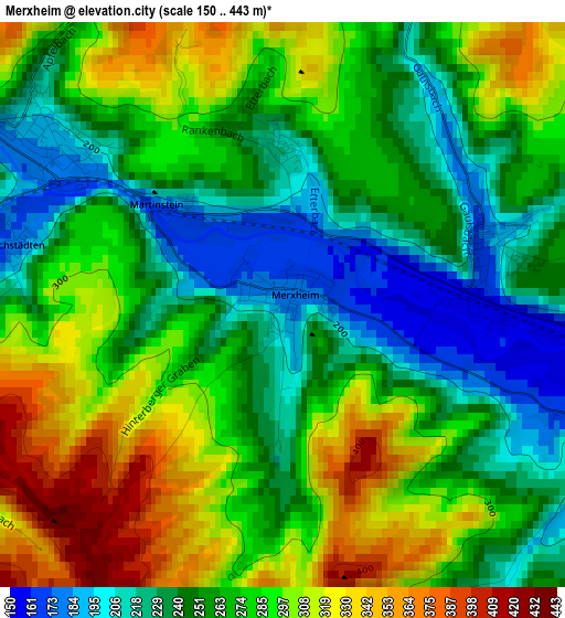
Below is the Elevation map of Merxheim, which displays elevation range with different colors. Scale of the first map is from 150 to 443 m (492 to 1453 ft) with average elevation of 270.5 meters (=887 ft) [note 1]
These maps also provides idea of topography and contour of this city, they are displayed at different zoom levels. More info about maps, scale and edge coordinates you can find below images.
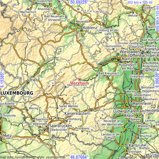
| \ | Map #1 | Topo.Map |
| Scale [m] | 150..443 m | × |
| Scale [ft] | 492..1453 ft | × |
| Average | 270.5 m = 887 ft | × |
| Width | 6.31 km = 3.9 mi | 201.9 km = 125.5 mi |
| Height | 6.31 km = 3.9 mi | 201.9 km = 125.5 mi |
| ↑Max Latitude | 49.821331° | 50.69228° |
| Latitude at center | 49.79297° | 49.79297° |
| ↓Min Latitude | 49.764593° | 48.87664° |
| ← Min Longitude | 7.516155° | 6.15385° |
| Longitude center | 7.5601° | 7.5601° |
| →Max Longitude | 7.604045° | 8.96635° |
Nearby cities:
Cities around Merxheim sort by population:
• Kirn elevation 201 m
7.4 km,  266°
266°
• Meisenheim 169 m
12.3 km,  140°
140°
• Waldböckelheim 194 m
11.5 km,  76°
76°
• Simmertal 189 m
3.3 km,  304°
304°
• Monzingen 184 m
2.4 km, 77°
• Odernheim 145 m
10.8 km,  106°
106°
• Hochstetten-Dhaun 250 m
4.4 km,  280°
280°
• Staudernheim 141 m
9.4 km,  101°
101°
• Meddersheim 165 m
4.5 km, 114°
• Hennweiler 358 m
9.5 km,  286°
286°
• Gemünden 283 m
12.7 km,  332°
332°
• Bockenau 238 m
9.9 km,  63°
63°
Multilingual:
 En español:
Merxheim elevación 180 m.
 En France:
Merxheim élévation 180 m.
 Auf Deutsch:
Merxheim höhe über dem Meeresspiegel ist 180 m.

Sources and notes:
- [note 1] Map square and city borders are not equal. Map elevation data is calculated only from area inside that square.
- [src 1] Elevation data from geonames database provided with same terms of usage.
- [src 2] The elevation map of Merxheim is generated using elevation data from NASA's 3 arcsec (90m) resolution SRTM data.
- [src 3] Base (background) map © OpenStreetMap contributors tiles are generated by Geofabrik and OpenTopoMap.
Copyright & License:
This Merxheim Elevation Map is licensed under CC BY-SA. You may reuse any part from this page, if you give a proper credit by linking to this URL:
 More info on terms of use page.