Mirow elevation
Mirow (Mecklenburg-Vorpommern), Germany elevation is 39 meters and Mirow elevation in feet is 128 ft above sea level [src 1]. Mirow is a populated place (feature code) with elevation that is 219 meters (719 ft) smaller than average city elevation in Germany.
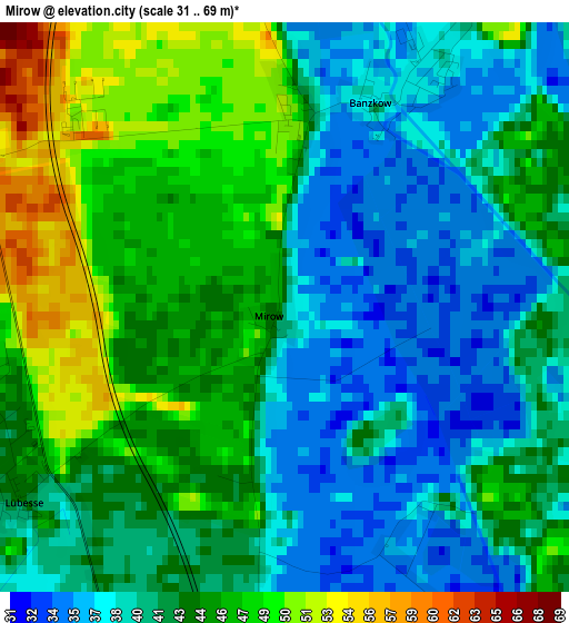
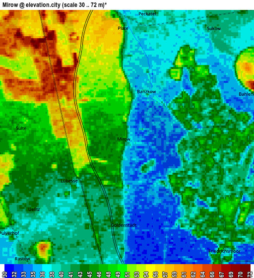
Below is the Elevation map of Mirow, which displays elevation range with different colors. Scale of the first map is from 31 to 69 m (102 to 226 ft) with average elevation of 42.4 meters (=139 ft) [note 1]
These maps also provides idea of topography and contour of this city, they are displayed at different zoom levels. More info about maps, scale and edge coordinates you can find below images.
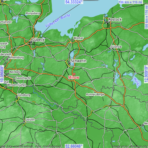
| \ | Map #1 | Map #2 | Topo.Map |
| Scale [m] | 31..69 m | 30..72 m | × |
| Scale [ft] | 102..226 ft | 98..236 ft | × |
| Average | 42.4 m = 139 ft | 44 m = 144 ft | × |
| Width | 5.81 km = 3.6 mi | 11.62 km = 7.2 mi | 186 km = 115.6 mi |
| Height | 5.81 km = 3.6 mi | 11.62 km = 7.2 mi | 186 km = 115.6 mi |
| ↑Max Latitude | 53.531228° | 53.557341° | 54.33324° |
| Latitude at center | 53.5051° | 53.5051° | 53.5051° |
| ↓Min Latitude | 53.478955° | 53.452795° | 52.66046° |
| ← Min Longitude | 11.458995° | 11.415049° | 10.09669° |
| Longitude center | 11.50294° | 11.50294° | 11.50294° |
| →Max Longitude | 11.546885° | 11.590831° | 12.90919° |
Nearby cities:
Cities around Mirow sort by population:
• Schwerin elevation 48 m
15 km,  336°
336°
• Crivitz 44 m
12.4 km,  52°
52°
• Feldstadt 47 m
14.6 km,  334°
334°
• Plate 38 m
5.2 km,  4°
4°
• Altstadt 47 m
14.8 km, 337°
• Banzkow 37 m
2.6 km,  31°
31°
• Pinnow 35 m
11.1 km,  14°
14°
• Rastow 41 m
7.1 km,  221°
221°
• Sukow 39 m
5.8 km,  41°
41°
• Klein Rogahn 46 m
15.2 km,  317°
317°
• Raben Steinfeld 57 m
10.7 km, 0°
• Sülstorf 45 m
8.5 km,  273°
273°
Multilingual:
 En español:
Mirow elevación 39 m.
 En France:
Mirow élévation 39 m.


Sources and notes:
- [note 1] Map square and city borders are not equal. Map elevation data is calculated only from area inside that square.
- [src 1] Elevation data from geonames database provided with same terms of usage.
- [src 2] The elevation map of Mirow is generated using elevation data from NASA's 3 arcsec (90m) resolution SRTM data.
- [src 3] Base (background) map © OpenStreetMap contributors tiles are generated by Geofabrik and OpenTopoMap.
Copyright & License:
This Mirow Elevation Map is licensed under CC BY-SA. You may reuse any part from this page, if you give a proper credit by linking to this URL:
 More info on terms of use page.