Schwerin elevation
Schwerin (Mecklenburg-Vorpommern), Germany elevation is 48 meters and Schwerin elevation in feet is 157 ft above sea level [src 1]. Schwerin is a seat of a first-order administrative division (feature code) with elevation that is 210 meters (689 ft) smaller than average city elevation in Germany.
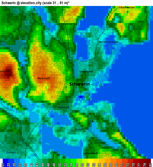
Below is the Elevation map of Schwerin, which displays elevation range with different colors. Scale of the first map is from 31 to 81 m (102 to 266 ft) with average elevation of 45.1 meters (=148 ft) [note 1]
These maps also provides idea of topography and contour of this city, they are displayed at different zoom levels. More info about maps, scale and edge coordinates you can find below images.
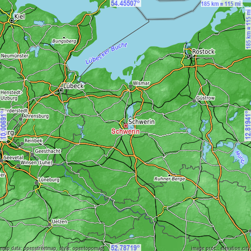
| \ | Map #1 | Map #2 | Topo.Map |
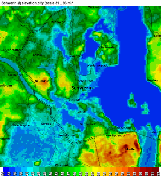
| Scale [m] | 31..81 m | 31..93 m | × |
| Scale [ft] | 102..266 ft | 102..305 ft | × |
| Average | 45.1 m = 148 ft | 47.9 m = 157 ft | × |
| Width | 5.8 km = 3.6 mi | 11.59 km = 7.2 mi | 185.5 km = 115.3 mi |
| Height | 5.8 km = 3.6 mi | 11.59 km = 7.2 mi | 185.4 km = 115.2 mi |
| ↑Max Latitude | 53.655422° | 53.681458° | 54.45507° |
| Latitude at center | 53.62937° | 53.62937° | 53.62937° |
| ↓Min Latitude | 53.603302° | 53.577218° | 52.78719° |
| ← Min Longitude | 11.369215° | 11.325269° | 10.00691° |
| Longitude center | 11.41316° | 11.41316° | 11.41316° |
| →Max Longitude | 11.457105° | 11.501051° | 12.81941° |
Nearby cities:
Cities around Schwerin sort by population:
• Weststadt elevation 65 m
1.3 km,  297°
297°
• Lankow 51 m
3.7 km,  308°
308°
• Paulsstadt 59 m
0.7 km, 301°
• Schelfstadt 42 m
0.6 km,  27°
27°
• Feldstadt 47 m
0.8 km,  212°
212°
• Werdervorstadt 42 m
1.4 km,  41°
41°
• Altstadt 47 m
0.2 km,  129°
129°
• Wittenförden 67 m
5.5 km,  269°
269°
• Neumühle 75 m
2.8 km,  275°
275°
• Leezen 66 m
6.7 km,  56°
56°
• Lewenberg 53 m
1.9 km,  348°
348°
• Klein Rogahn 46 m
5.2 km,  238°
238°
Multilingual:
 En español:
Schwerin elevación 48 m.
 En France:
Schwerin élévation 48 m.


Sources and notes:
- [note 1] Map square and city borders are not equal. Map elevation data is calculated only from area inside that square.
- [src 1] Elevation data from geonames database provided with same terms of usage.
- [src 2] The elevation map of Schwerin is generated using elevation data from NASA's 3 arcsec (90m) resolution SRTM data.
- [src 3] Base (background) map © OpenStreetMap contributors tiles are generated by Geofabrik and OpenTopoMap.
Copyright & License:
This Schwerin Elevation Map is licensed under CC BY-SA. You may reuse any part from this page, if you give a proper credit by linking to this URL:
 More info on terms of use page.