Mönchsdeggingen elevation
Mönchsdeggingen (Bavaria, Swabia), Germany elevation is 434 meters and Mönchsdeggingen elevation in feet is 1424 ft above sea level [src 1]. Mönchsdeggingen is a seat of a fourth-order administrative division (feature code) with elevation that is 176 meters (577 ft) bigger than average city elevation in Germany.
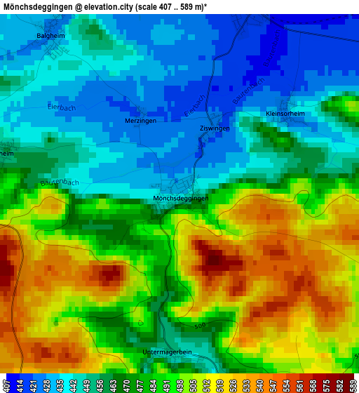
Below is the Elevation map of Mönchsdeggingen, which displays elevation range with different colors. Scale of the first map is from 407 to 589 m (1335 to 1932 ft) with average elevation of 474.3 meters (=1556 ft) [note 1]
These maps also provides idea of topography and contour of this city, they are displayed at different zoom levels. More info about maps, scale and edge coordinates you can find below images.
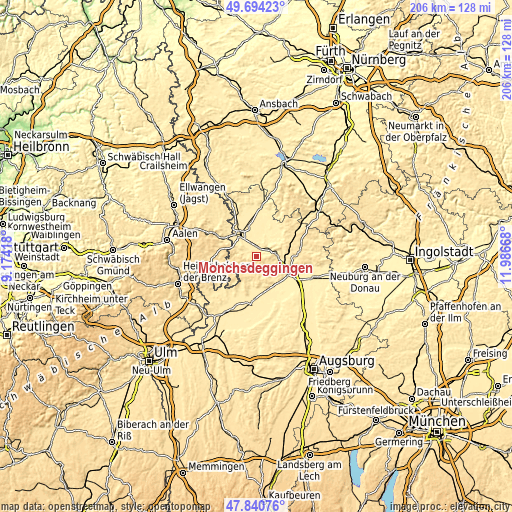
| \ | Map #1 | Topo.Map |
| Scale [m] | 407..589 m | × |
| Scale [ft] | 1335..1932 ft | × |
| Average | 474.3 m = 1556 ft | × |
| Width | 6.44 km = 4 mi | 206.1 km = 128.1 mi |
| Height | 6.44 km = 4 mi | 206.1 km = 128.1 mi |
| ↑Max Latitude | 48.805002° | 49.69423° |
| Latitude at center | 48.77605° | 48.77605° |
| ↓Min Latitude | 48.747082° | 47.84076° |
| ← Min Longitude | 10.536485° | 9.17418° |
| Longitude center | 10.58043° | 10.58043° |
| →Max Longitude | 10.624375° | 11.98668° |
Nearby cities:
Cities around Mönchsdeggingen sort by population:
• Nördlingen elevation 437 m
10.7 km,  321°
321°
• Harburg 411 m
8.1 km,  81°
81°
• Tapfheim 414 m
13.7 km,  146°
146°
• Bissingen 443 m
7.1 km,  157°
157°
• Wallerstein 450 m
14.6 km,  328°
328°
• Möttingen 416 m
3.8 km,  10°
10°
• Deiningen 421 m
10.1 km,  354°
354°
• Alerheim 413 m
8.6 km,  17°
17°
• Huisheim 446 m
10.5 km,  58°
58°
• Wechingen 412 m
13.1 km, 10°
• Reimlingen 449 m
6.5 km,  314°
314°
• Ederheim 472 m
9.1 km,  293°
293°
Multilingual:
 En español:
Mönchsdeggingen elevación 434 m.
 En France:
Mönchsdeggingen élévation 434 m.
 Auf Deutsch:
Mönchsdeggingen höhe über dem Meeresspiegel ist 434 m.

Sources and notes:
- [note 1] Map square and city borders are not equal. Map elevation data is calculated only from area inside that square.
- [src 1] Elevation data from geonames database provided with same terms of usage.
- [src 2] The elevation map of Mönchsdeggingen is generated using elevation data from NASA's 3 arcsec (90m) resolution SRTM data.
- [src 3] Base (background) map © OpenStreetMap contributors tiles are generated by Geofabrik and OpenTopoMap.
Copyright & License:
This Mönchsdeggingen Elevation Map is licensed under CC BY-SA. You may reuse any part from this page, if you give a proper credit by linking to this URL:
 More info on terms of use page.