Moos elevation
Moos (Baden-Württemberg, Freiburg Region), Germany elevation is 400 meters and Moos elevation in feet is 1312 ft above sea level [src 1]. Moos is a seat of a fourth-order administrative division (feature code) with elevation that is 142 meters (466 ft) bigger than average city elevation in Germany.
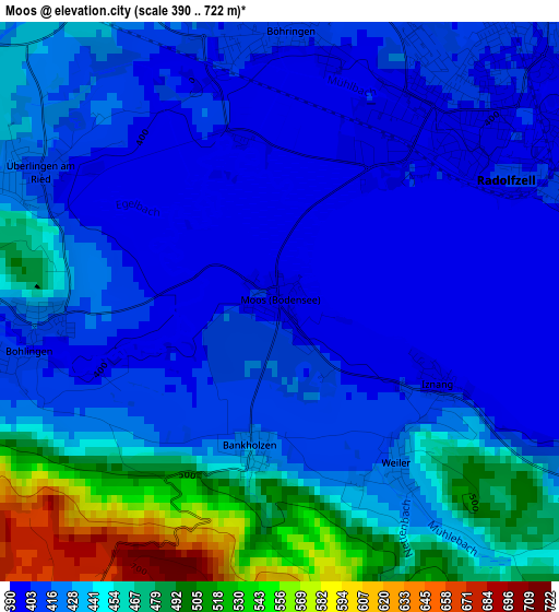
Below is the Elevation map of Moos, which displays elevation range with different colors. Scale of the first map is from 390 to 722 m (1280 to 2369 ft) with average elevation of 434.5 meters (=1426 ft) [note 1]
These maps also provides idea of topography and contour of this city, they are displayed at different zoom levels. More info about maps, scale and edge coordinates you can find below images.
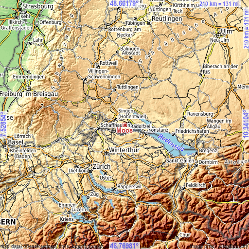
| \ | Map #1 | Topo.Map |
| Scale [m] | 390..722 m | × |
| Scale [ft] | 1280..2369 ft | × |
| Average | 434.5 m = 1426 ft | × |
| Width | 6.57 km = 4.1 mi | 210.4 km = 130.7 mi |
| Height | 6.57 km = 4.1 mi | 210.4 km = 130.7 mi |
| ↑Max Latitude | 47.753944° | 48.66179° |
| Latitude at center | 47.72439° | 47.72439° |
| ↓Min Latitude | 47.69482° | 46.76981° |
| ← Min Longitude | 8.890845° | 7.52854° |
| Longitude center | 8.93479° | 8.93479° |
| →Max Longitude | 8.978735° | 10.34104° |
Nearby cities:
Cities around Moos sort by population:
• Singen elevation 436 m
8.1 km,  298°
298°
• Radolfzell 403 m
3.3 km,  54°
54°
• Rielasingen-Worblingen 421 m
7.2 km,  279°
279°
• Gottmadingen 428 m
11.9 km, 275°
• Hilzingen 468 m
12.3 km,  292°
292°
• Allensbach 403 m
10.3 km,  95°
95°
• Reichenau 409 m
10.4 km,  112°
112°
• Steißlingen 465 m
8.4 km,  359°
359°
• Öhningen 447 m
7.8 km,  207°
207°
• Gaienhofen 426 m
5.8 km,  141°
141°
• Orsingen-Nenzingen 460 m
13.3 km,  7°
7°
• Volkertshausen 445 m
11.5 km,  333°
333°
Multilingual:
 En español:
Moos elevación 400 m.
 En France:
Moos élévation 400 m.


Sources and notes:
- [note 1] Map square and city borders are not equal. Map elevation data is calculated only from area inside that square.
- [src 1] Elevation data from geonames database provided with same terms of usage.
- [src 2] The elevation map of Moos is generated using elevation data from NASA's 3 arcsec (90m) resolution SRTM data.
- [src 3] Base (background) map © OpenStreetMap contributors tiles are generated by Geofabrik and OpenTopoMap.
Copyright & License:
This Moos Elevation Map is licensed under CC BY-SA. You may reuse any part from this page, if you give a proper credit by linking to this URL:
 More info on terms of use page.