Mühlingen elevation
Mühlingen (Baden-Württemberg, Freiburg Region), Germany elevation is 614 meters and Mühlingen elevation in feet is 2014 ft above sea level [src 1]. Mühlingen is a seat of a fourth-order administrative division (feature code) with elevation that is 356 meters (1168 ft) bigger than average city elevation in Germany.
Below is the Elevation map of Mühlingen, which displays elevation range with different colors. Scale of the first map is from 538 to 710 m (1765 to 2329 ft) with average elevation of 643.6 meters (=2112 ft) [note 1]
These maps also provides idea of topography and contour of this city, they are displayed at different zoom levels. More info about maps, scale and edge coordinates you can find below images.
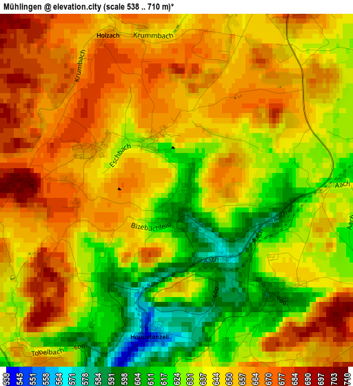
| \ | Map #1 | Topo.Map |
| Scale [m] | 538..710 m | × |
| Scale [ft] | 1765..2329 ft | × |
| Average | 643.6 m = 2112 ft | × |
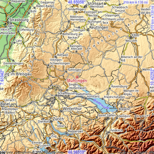
| Width | 6.55 km = 4.1 mi | 209.6 km = 130.2 mi |
| Height | 6.55 km = 4.1 mi | 209.6 km = 130.2 mi |
| ↑Max Latitude | 47.946114° | 48.85058° |
| Latitude at center | 47.91667° | 47.91667° |
| ↓Min Latitude | 47.887209° | 46.96559° |
| ← Min Longitude | 8.972725° | 7.61042° |
| Longitude center | 9.01667° | 9.01667° |
| →Max Longitude | 9.060615° | 10.42292° |
Nearby cities:
Cities around Mühlingen sort by population:
• Stockach elevation 474 m
7.3 km,  184°
184°
• Meßkirch 603 m
11.3 km,  40°
40°
• Emmingen-Liptingen 742 m
10.1 km,  280°
280°
• Steißlingen 465 m
14.4 km,  205°
205°
• Rot 657 m
6.6 km,  84°
84°
• Bodman-Ludwigshafen 405 m
11.3 km,  165°
165°
• Eigeltingen 482 m
11 km,  233°
233°
• Fridingen an der Donau 627 m
13.4 km,  328°
328°
• Orsingen-Nenzingen 460 m
9.3 km, 207°
• Wald 657 m
11.3 km, 80°
• Sauldorf 621 m
7.5 km,  66°
66°
• Leibertingen 797 m
14 km,  358°
358°
Multilingual:
 En español:
Mühlingen elevación 614 m.
 En France:
Mühlingen élévation 614 m.
 Auf Deutsch:
Mühlingen höhe über dem Meeresspiegel ist 614 m.

Sources and notes:
- [note 1] Map square and city borders are not equal. Map elevation data is calculated only from area inside that square.
- [src 1] Elevation data from geonames database provided with same terms of usage.
- [src 2] The elevation map of Mühlingen is generated using elevation data from NASA's 3 arcsec (90m) resolution SRTM data.
- [src 3] Base (background) map © OpenStreetMap contributors tiles are generated by Geofabrik and OpenTopoMap.
Copyright & License:
This Mühlingen Elevation Map is licensed under CC BY-SA. You may reuse any part from this page, if you give a proper credit by linking to this URL:
 More info on terms of use page.