Nauendorf elevation
Nauendorf (Saxony-Anhalt), Germany elevation is 144 meters and Nauendorf elevation in feet is 472 ft above sea level [src 1]. Nauendorf is a populated place (feature code) with elevation that is 114 meters (374 ft) smaller than average city elevation in Germany.
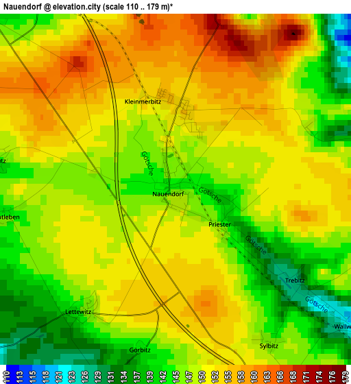
Below is the Elevation map of Nauendorf, which displays elevation range with different colors. Scale of the first map is from 110 to 179 m (361 to 587 ft) with average elevation of 148.9 meters (=489 ft) [note 1]
These maps also provides idea of topography and contour of this city, they are displayed at different zoom levels. More info about maps, scale and edge coordinates you can find below images.
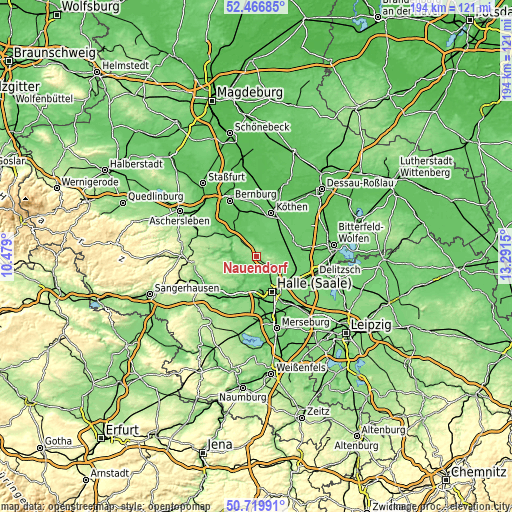
| \ | Map #1 | Topo.Map |
| Scale [m] | 110..179 m | × |
| Scale [ft] | 361..587 ft | × |
| Average | 148.9 m = 489 ft | × |
| Width | 6.07 km = 3.8 mi | 194.2 km = 120.7 mi |
| Height | 6.07 km = 3.8 mi | 194.2 km = 120.7 mi |
| ↑Max Latitude | 51.629067° | 52.46685° |
| Latitude at center | 51.60178° | 51.60178° |
| ↓Min Latitude | 51.574476° | 50.71991° |
| ← Min Longitude | 11.841305° | 10.479° |
| Longitude center | 11.88525° | 11.88525° |
| →Max Longitude | 11.929195° | 13.2915° |
Nearby cities:
Cities around Nauendorf sort by population:
• Könnern elevation 97 m
11 km,  314°
314°
• Gröbzig 80 m
9 km,  355°
355°
• Lieskau 102 m
11 km,  188°
188°
• Salzmünde 74 m
9.3 km,  205°
205°
• Löbejün 115 m
3.9 km,  16°
16°
• Wettin 98 m
5.7 km,  252°
252°
• Sennewitz 86 m
8 km,  144°
144°
• Teicha 102 m
6.8 km,  134°
134°
• Trebitz 135 m
2.9 km, 126°
• Görzig 81 m
10.4 km,  48°
48°
• Gutenberg 101 m
8.5 km, 135°
• Wallwitz 120 m
3.8 km, 128°
Multilingual:
 En español:
Nauendorf elevación 144 m.
 En France:
Nauendorf élévation 144 m.
 Auf Deutsch:
Nauendorf höhe über dem Meeresspiegel ist 144 m.

Sources and notes:
- [note 1] Map square and city borders are not equal. Map elevation data is calculated only from area inside that square.
- [src 1] Elevation data from geonames database provided with same terms of usage.
- [src 2] The elevation map of Nauendorf is generated using elevation data from NASA's 3 arcsec (90m) resolution SRTM data.
- [src 3] Base (background) map © OpenStreetMap contributors tiles are generated by Geofabrik and OpenTopoMap.
Copyright & License:
This Nauendorf Elevation Map is licensed under CC BY-SA. You may reuse any part from this page, if you give a proper credit by linking to this URL:
 More info on terms of use page.