Salzmünde elevation
Salzmünde (Saxony-Anhalt), Germany elevation is 74 meters and Salzmünde elevation in feet is 243 ft above sea level [src 1]. Salzmünde is a populated place (feature code) with elevation that is 184 meters (604 ft) smaller than average city elevation in Germany.
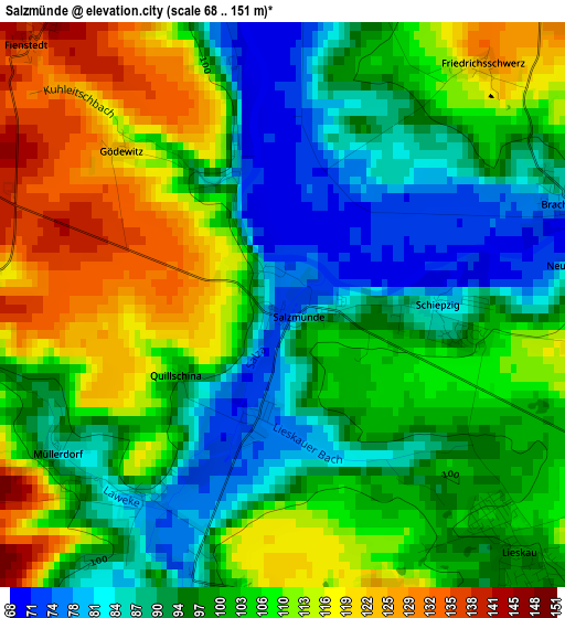
Below is the Elevation map of Salzmünde, which displays elevation range with different colors. Scale of the first map is from 68 to 151 m (223 to 495 ft) with average elevation of 101.8 meters (=334 ft) [note 1]
These maps also provides idea of topography and contour of this city, they are displayed at different zoom levels. More info about maps, scale and edge coordinates you can find below images.
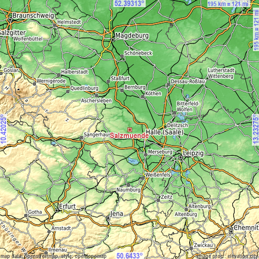
| \ | Map #1 | Topo.Map |
| Scale [m] | 68..151 m | × |
| Scale [ft] | 223..495 ft | × |
| Average | 101.8 m = 334 ft | × |
| Width | 6.08 km = 3.8 mi | 194.6 km = 120.9 mi |
| Height | 6.08 km = 3.8 mi | 194.5 km = 120.9 mi |
| ↑Max Latitude | 51.553952° | 52.39313° |
| Latitude at center | 51.52662° | 51.52662° |
| ↓Min Latitude | 51.499271° | 50.6433° |
| ← Min Longitude | 11.782555° | 10.42025° |
| Longitude center | 11.8265° | 11.8265° |
| →Max Longitude | 11.870445° | 13.23275° |
Nearby cities:
Cities around Salzmünde sort by population:
• Halle Neustadt elevation 85 m
8.1 km,  130°
130°
• Teutschenthal 119 m
8.7 km,  192°
192°
• Lieskau 102 m
3.5 km,  135°
135°
• Wettin 98 m
6.8 km,  348°
348°
• Langenbogen 91 m
5.9 km,  214°
214°
• Sennewitz 86 m
8.9 km,  77°
77°
• Höhnstedt 160 m
6.6 km,  246°
246°
• Zscherben 106 m
7.3 km,  155°
155°
• Zappendorf 89 m
2.8 km,  229°
229°
• Bennstedt 90 m
5 km,  180°
180°
• Schochwitz 117 m
5 km,  276°
276°
• Beesenstedt 172 m
7.9 km,  305°
305°
Multilingual:
 En español:
Salzmünde elevación 74 m.
 En France:
Salzmünde élévation 74 m.
 Auf Deutsch:
Salzmünde höhe über dem Meeresspiegel ist 74 m.

Sources and notes:
- [note 1] Map square and city borders are not equal. Map elevation data is calculated only from area inside that square.
- [src 1] Elevation data from geonames database provided with same terms of usage.
- [src 2] The elevation map of Salzmünde is generated using elevation data from NASA's 3 arcsec (90m) resolution SRTM data.
- [src 3] Base (background) map © OpenStreetMap contributors tiles are generated by Geofabrik and OpenTopoMap.
Copyright & License:
This Salzmünde Elevation Map is licensed under CC BY-SA. You may reuse any part from this page, if you give a proper credit by linking to this URL:
 More info on terms of use page.