Neidlingen elevation
Neidlingen (Baden-Württemberg, Regierungsbezirk Stuttgart), Germany elevation is 457 meters and Neidlingen elevation in feet is 1499 ft above sea level [src 1]. Neidlingen is a seat of a fourth-order administrative division (feature code) with elevation that is 199 meters (653 ft) bigger than average city elevation in Germany.
Below is the Elevation map of Neidlingen, which displays elevation range with different colors. Scale of the first map is from 399 to 827 m (1309 to 2713 ft) with average elevation of 633.8 meters (=2079 ft) [note 1]
These maps also provides idea of topography and contour of this city, they are displayed at different zoom levels. More info about maps, scale and edge coordinates you can find below images.
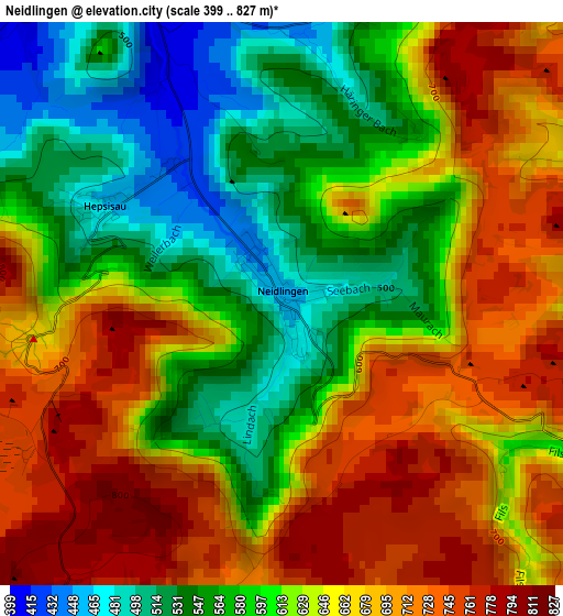
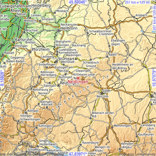
| \ | Map #1 | Topo.Map |
| Scale [m] | 399..827 m | × |
| Scale [ft] | 1309..2713 ft | × |
| Average | 633.8 m = 2079 ft | × |
| Width | 6.47 km = 4 mi | 206.9 km = 128.6 mi |
| Height | 6.47 km = 4 mi | 206.9 km = 128.6 mi |
| ↑Max Latitude | 48.607715° | 49.50046° |
| Latitude at center | 48.57865° | 48.57865° |
| ↓Min Latitude | 48.549568° | 47.63971° |
| ← Min Longitude | 9.520595° | 8.15829° |
| Longitude center | 9.56454° | 9.56454° |
| →Max Longitude | 9.608485° | 10.97079° |
Nearby cities:
Cities around Neidlingen sort by population:
• Weilheim an der Teck elevation 383 m
4.6 km,  334°
334°
• Lenningen 466 m
7.2 km,  244°
244°
• Boll 416 m
8 km,  26°
26°
• Bissingen an der Teck 418 m
5.8 km,  292°
292°
• Zell unter Aichelberg 383 m
7.8 km,  3°
3°
• Westerheim 816 m
8.3 km,  148°
148°
• Gruibingen 566 m
6.1 km,  72°
72°
• Wiesensteig 590 m
4.9 km,  113°
113°
• Holzmaden 356 m
7 km, 329°
• Ohmden 360 m
8 km,  339°
339°
• Aichelberg 434 m
6.3 km,  359°
359°
• Mühlhausen 542 m
6.8 km,  91°
91°
Multilingual:
 En español:
Neidlingen elevación 457 m.
 En France:
Neidlingen élévation 457 m.
 Auf Deutsch:
Neidlingen höhe über dem Meeresspiegel ist 457 m.

Sources and notes:
- [note 1] Map square and city borders are not equal. Map elevation data is calculated only from area inside that square.
- [src 1] Elevation data from geonames database provided with same terms of usage.
- [src 2] The elevation map of Neidlingen is generated using elevation data from NASA's 3 arcsec (90m) resolution SRTM data.
- [src 3] Base (background) map © OpenStreetMap contributors tiles are generated by Geofabrik and OpenTopoMap.
Copyright & License:
This Neidlingen Elevation Map is licensed under CC BY-SA. You may reuse any part from this page, if you give a proper credit by linking to this URL:
 More info on terms of use page.